|
|
vol 8 num 2

from VizMAP – letting you see where you stand…
Volume 8 Number 2
|
About VizMAP
VizMAP Pty Ltd, is a leading supplier of terrain Visualisation and related services to the defence, GIS, environmental, mapping, mining and exploration industries, engineering and construction firms, developers and planners, as well as government administration departments dealing with land, transportation and the environment.
VizMAP’s products are designed to be run on reasonably to highly configured graphics computers (PC, Linux and Unix) for public display, group training, mission rehearsal, environmental monitoring, etc. and to enhance management decision making.
VizMAP is headquartered on Queensland’s Sunshine Coast (Australia) with affiliation in Asia, Europe, Africa and the USA and thereby provides support and services to customers worldwide.
If you need to visualise anything geographic, e-mail VizMAP here with the details.
For more information about VizMAP visit the VizMAP Web site at http://www.vizmap.com.au.
|
VirtualGeography
Subscription
Details
To subscribe to VirtualGeography,
click here.
To unsubscribe from VirtualGeography,
click here.
|
|
"The major difference between a thing that might go wrong and a thing that cannot possibly go wrong is that when a thing that cannot possibly go wrong goes wrong it usually turns out to be impossible to get at or repair."
— One of the laws of computers and programming revealed. Douglas Adams in "Mostly Harmless"
|
|
VirtualGeography – the newsletter
|
| G’Day… and Welcome to VirtualGeography |
from VizMAP |
| Welcome to another free VirtualGeography from VizMAP Pty Ltd.
You are receiving this either because you subscribed to VirtualGeography or you have had recent dealings with VizMAP Pty Ltd. If you do not wish to receive further installments of VirtualGeography, just click on the unsubscribe link at the bottom of this e-mail.
A couple of significant things have happened, web-wise, since the last VirtualGeography popped out. Firstly, the VizMAP web hosting has been changed once more and the entire site has been revamped, renewed and rebuilt using WordPress. If you haven’t seen the new VizMAP website, have a look at it here. Feedback is encouraged – let me know here.
Interestingly, my VirtualGeography backup was corrupted and I’m missing vol.5 no.4 from November 2006. If anyone happens to have it, I’d like to build it back into the new archive here, so please let me know, or just send it. Thanks in advance!
The second webby thing that happened is that VizMAP’s sister site Grime was moved to a new host (as well) which wouldn’t have been interesting except it was the Grime mail server that was hosting the mailing list for VirtualGeography and it went >>POOF<< before I realised what had happened! Consequently, I have had to revert to a backup mailing list that was created last November. A few of you who may have unsubscribed through the list server since then may find yourselves back on the list and for that, I apologise. I’m reverting to a manual subscribe/unsubscribe procedure for the time being, so please let me know here if you want to unsubscribe.
On the business front, the new VBS2 Export plugin for TerraTools has generated huge interest within Australian Defence and in the associated Defence subcontractor community – as well as from our neigbours across the Tasman. This was never more apparent than at the recent Simulation Training and Technology conference (SimTecT) in Adelaide in June. VizMAP was represented on the Calytrix booth alongside Bohemia Interactive, the makers of VBS2.
If you didn’t already know, VirtualGeography is a collection of interesting snippets from all over the shop, dealing with industry issues concerning the computer based visualisation of geography and a few other associated (or otherwise) interesting bits and pieces.
A new VirtualGeography is pushed out every now and then when we’ve collated enough interesting bits and pieces, which shouldn’t be too big a drain on your mailbox if you’re not already subscribed (of course it won’t be a drain on your mailbox if you ARE subscribed, either  ). The regularity of the distribution may vary depending on what else is going on at VizMAP at the time. If you know of anyone who might like to get VirtualGeography, feel free to forward this to them and ask them to subscribe. By the way, subscription and unsubscription details are at the bottom (click here). ). The regularity of the distribution may vary depending on what else is going on at VizMAP at the time. If you know of anyone who might like to get VirtualGeography, feel free to forward this to them and ask them to subscribe. By the way, subscription and unsubscription details are at the bottom (click here).
So, g’day to all you enthusiasts requiring to visualise and/or simulate both urban and rural geographic information (GIS), cartography, photogrammetry, remote sensing, digital elevation modelling (DEM) and general mapping.By the spelling of "Visualisation" you may have already guessed that we’re not US based – that’s a good thing, or at least not a bad thing. This comes to you from Mooloolaba on the Sunshine Coast of Queensland, Australia, where it’s beautiful one day and perfect the next. As a postscript to that, you can have a look at the Mooloolaba beach, now, 800m from where I sit as I write this, here.
|
The link between visualisation and mapping may seem a little esoteric if this is your first encounter with this sort of stuff, but let me tell you, the bond is significant… but enough of that: on with the show…
I hope you like it. Any feedback you might have is highly appreciated. E-mail me here to make your comments.
Enjoy…
Graeme Brooke
VizMAP Pty Ltd
|
 |
P.S. You’ll need an active internet connection to view any images that are in the content. We’ve done it this way to keep the size of the e-mail to a minimum.
|
| |
Back to Top |
The Industry’s
Two Cents Worth… |
TerraTools Exporter for Virtual Battlespace 2 (VBS2) Now Available
|
from TerraSim |
|
Pittsburgh, PA – TerraSim, Inc. is pleased to announce that the full release of the TerraTools Exporter for Virtual Battlespace 2 (VBS2) is now available for customer download from TerraSim’s support website.
Virtual Battlespace 2 is a fully interactive, three-dimensional training system that provides a premium synthetic environment suitable for a wide range of military (or similar) training and experimentation purposes. Developed by Bohemia Interactive Australia (BIA), VBS2 offers both virtual and constructive interfaces onto high-fidelity worlds of unparalleled realism. VBS2 is used by military organizations worldwide for mission rehearsal, tactical training, and simulated combined arms exercises. To learn more about VBS2, visit www.vbs2.com.
TerraSim’s VBS2 exporter plug-in extends TerraTools’ impressive range of capabilities to export 3D terrain databases correlated for both visual simulation and semi-automated forces (SAF) applications of constructive simulation. Real-time interaction between VBS2 and the US Army’s OneSAF runtime environment, interconnected via the Calytrix LVC Game interface and using correlated terrains produced by TerraTools, generated significant interest at I/ITSEC in December of 2008. These correlated terrain databases, as well as databases in OpenFlight 16.0, JCATS 7.1.5, JSAF (CTDB8), OneSAF Testbed (OTF) (CTDB7), and MÄK VR-Forces, are available for download from the Calytrix website.
In these databases, TerraTools Urban Details processing generates and converts roof clutter, free-standing walls, buildings with interiors, and power lines with wires into the equivalent VBS2 runtime format employing user-defined appearances and clutter. Both simple buildings and those with interiors, windows, and doors can be automatically created.
Urban Details processing can be tailored to adjust to user requirements for model placement including density, model vanishing ranges, and levels of detail. Models can be used from the standard TerraTools model library or users can organize their models into regionally or culturally specific groups. In addition to automatic model placement and alignment using geometric constraints, model groups can be constructed and scripted to avoid simple repetition.
Models that are specifically constructed for VBS2 in any of the BIA toolsets can be placed in the TerraTools generated VBS2 environments, giving them a full range of runtime effects, including dynamic damage states. Models created in 3DStudioMax and OpenFlight can be converted using TerraTools and the free 3DStudioMax plug-in. Extruded buildings or buildings with interiors created from GIS/VMAP data can also be used.
|
| Read that full story here |
Back to Top |
Hardcore Stuff
(hardware bits)… |
Oracle to Buy Sun
|
from Sun |
| SANTA CLARA, Calif. April 20, 2009 Sun Microsystems (NASDAQ: JAVA) and Oracle Corporation (NASDAQ: ORCL) announced today they have entered into a definitive agreement under which Oracle will acquire Sun common stock for $9.50 per share in cash. The transaction is valued at approximately $7.4 billion, or $5.6 billion net of Sun’s cash and debt.
"We expect this acquisition to be accretive to Oracle’s earnings by at least 15 cents on a non-GAAP basis in the first full year after closing. We estimate that the acquired business will contribute over $1.5 billion to Oracle’s non-GAAP operating profit in the first year, increasing to over $2 billion in the second year. This would make the Sun acquisition more profitable in per share contribution in the first year than we had planned for the acquisitions of BEA, PeopleSoft and Siebel combined," said Oracle President Safra Catz.
"The acquisition of Sun transforms the IT industry, combining best-in-class enterprise software and mission-critical computing systems," said Oracle CEO Larry Ellison. "Oracle will be the only company that can engineer an integrated system – applications to disk – where all the pieces fit and work together so customers do not have to do it themselves. Our customers benefit as their systems integration costs go down while system performance, reliability and security go up."
There are substantial long-term strategic customer advantages to Oracle owning two key Sun software assets: Java and Solaris. Java is one of the computer industry’s best-known brands and most widely deployed technologies, and it is the most important software Oracle has ever acquired. Oracle Fusion Middleware, Oracle’s fastest growing business, is built on top of Sun’s Java language and software. Oracle can now ensure continued innovation and investment in Java technology for the benefit of customers and the Java community.
The Sun Solaris operating system is the leading platform for the Oracle database, Oracle’s largest business, and has been for a long time. With the acquisition of Sun, Oracle can optimize the Oracle database for some of the unique, high-end features of Solaris. Oracle is as committed as ever to Linux and other open platforms and will continue to support and enhance our strong industry partnerships.
"Oracle and Sun have been industry pioneers and close partners for more than 20 years," said Sun Chairman Scott McNealy. "This combination is a natural evolution of our relationship and will be an industry-defining event."
"This is a fantastic day for Sun’s customers, developers, partners and employees across the globe, joining forces with the global leader in enterprise software to drive innovation and value across every aspect of the technology marketplace," said Jonathan Schwartz, Sun’s CEO, "From the Java platform touching nearly every business system on earth, powering billions of consumers on mobile handsets and consumer electronics, to the convergence of storage, networking and computing driven by the Solaris operating system and Sun’s SPARC and x64 systems. Together with Oracle, we’ll drive the innovation pipeline to create compelling value to our customer base and the marketplace."
"Sun is a pioneer in enterprise computing, and this combination recognizes the innovation and customer success the company has achieved. Our largest customers have been asking us to step up to a broader role to reduce complexity, risk and cost by delivering a highly optimized stack based on standards," said Oracle President Charles Phillips. "This transaction will preserve and enhance investments made by our customers, while we continue to work with our partners to provide customers with choice."
The Board of Directors of Sun Microsystems has unanimously approved the transaction. It is anticipated to close this summer, subject to Sun stockholder approval, certain regulatory approvals and customary closing conditions. |
| Read that full story here |
Back to Top |
Softcore Stuff
(software & data bits)… |
| Measuring the Great Wall of China |
from ASM |
| How long is China’s Great Wall? One reason the question is so hard to answer is that the wall is discontinuous. Parts of it are built from stone, parts from rammed Earth. In places it is little more that a ditch, and in some places there is no wall at all, just fortifications along natural barriers such as rivers.
To add to the complexity, the earliest fortifications date to the first emperor of China, Qin Shi Huang. Some of these can still be seen today but most of the modern wall dates from the Ming dynasty (before 1700 AD).
Another reason it is so hard to measure the length of the Great Wall is that in some parts, the wall is built over the steepest parts of mountainous areas. Traditional field surveying could not easily measure its real length in 3D space.
Recently, the International Society of Photogrammetry and Remote Sensing sponsored a project to determine the true length of the wall. ISPRS president Chen Jun was the chief scientist on the project. He led a team of about 800 professionals from geomatics and cultural heritage disciplines.
The team used 1:35,000 air photos to generate a 3D digital model of the topography. This allowed the team to measure the slope length using digital photogrammetric tools.
On 18 April, they revealed that the Great Wall built in the Ming Dynasty era stretched 8851.8 km, further than the previous estimate of around 6000 km. It consists of 6259.6 km of stone wall, 359.7 km of trench wall, and 2232.5 kilometers of natural defensive barriers such as hills and rivers. |
| Read that full story here |
Back to Top |
Desert Village
|
from VizMAP |
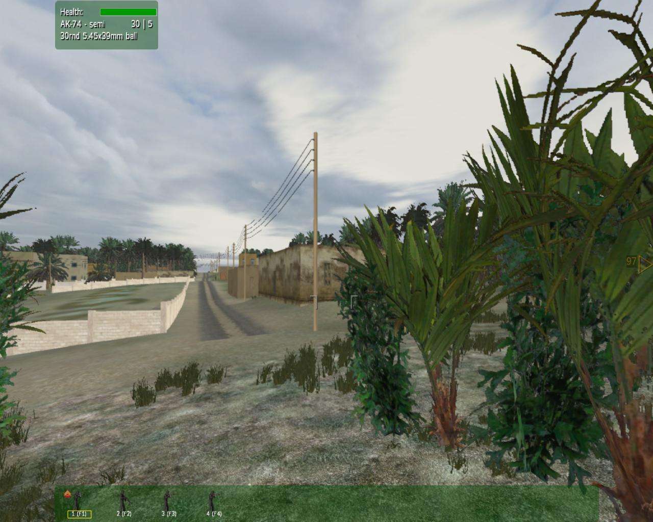
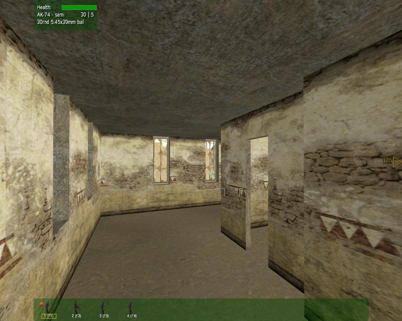
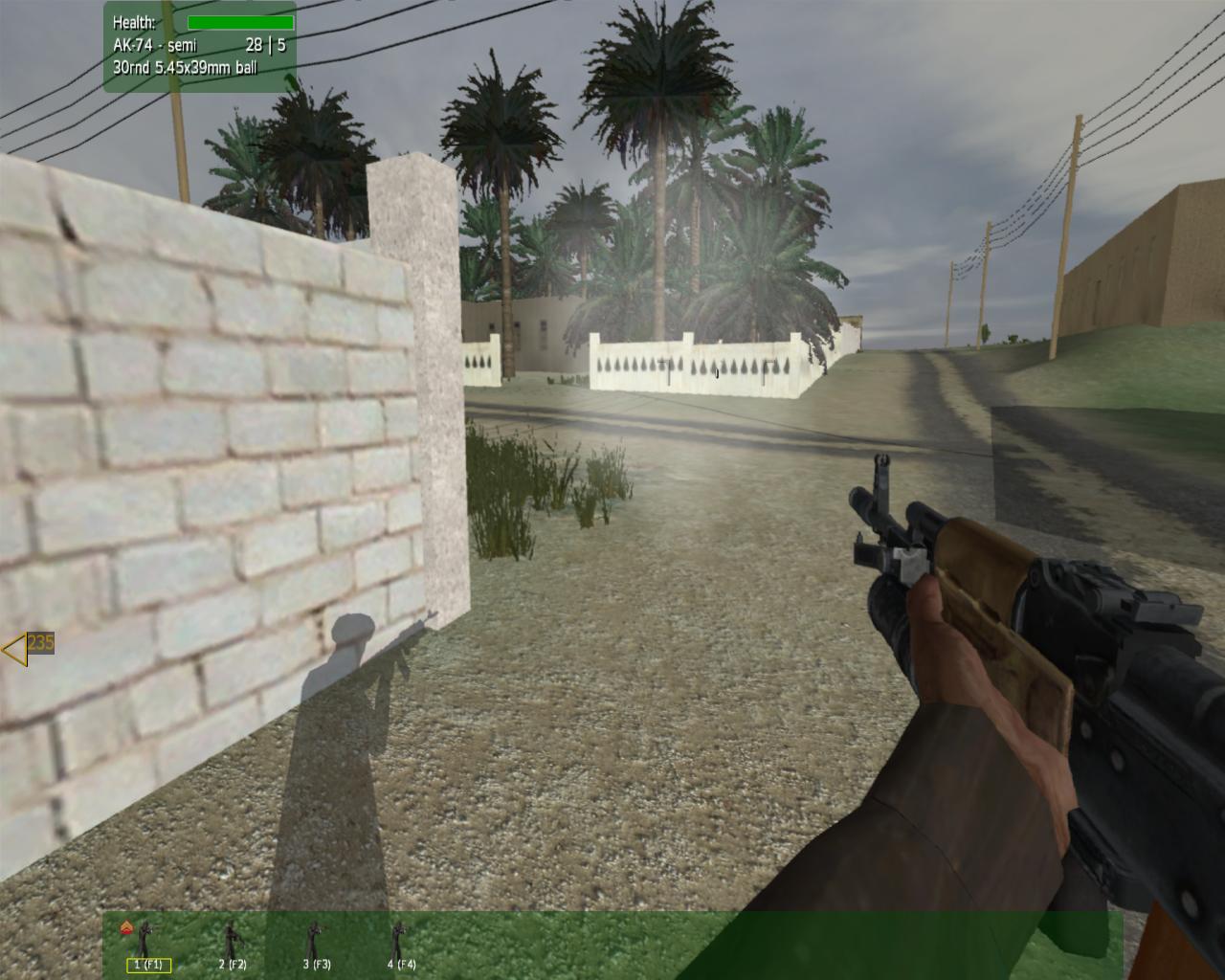
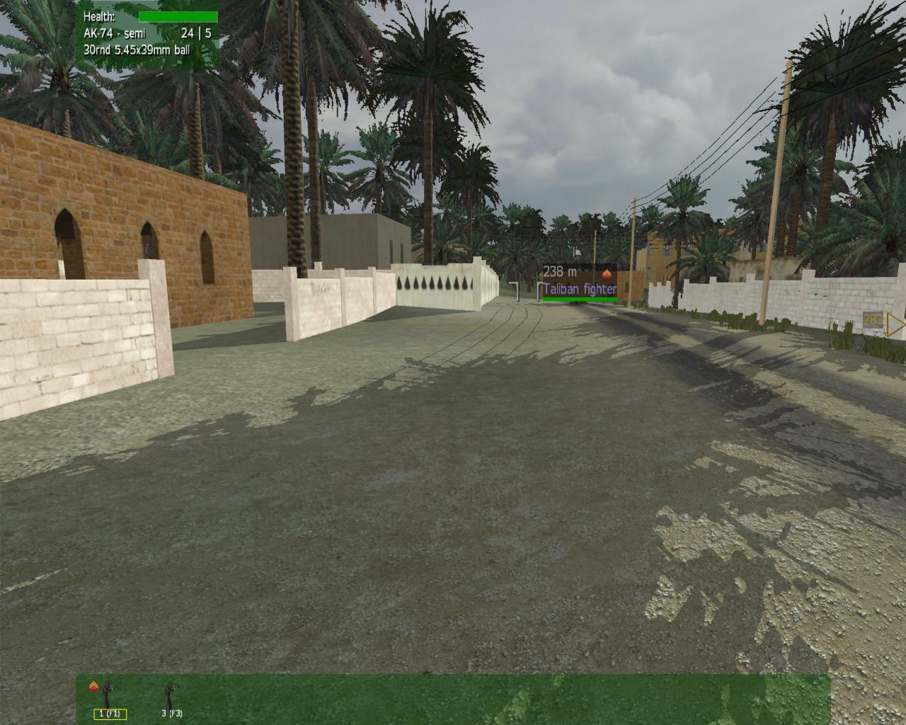
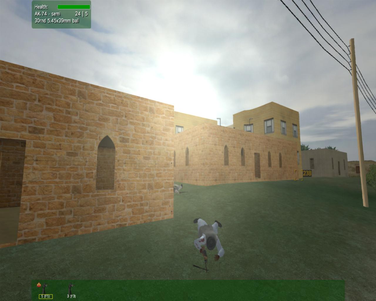
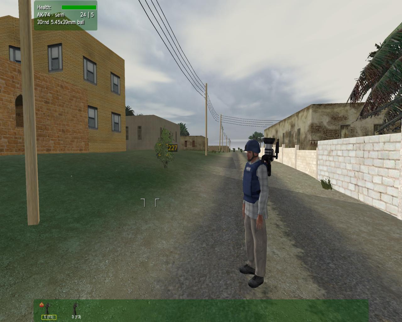
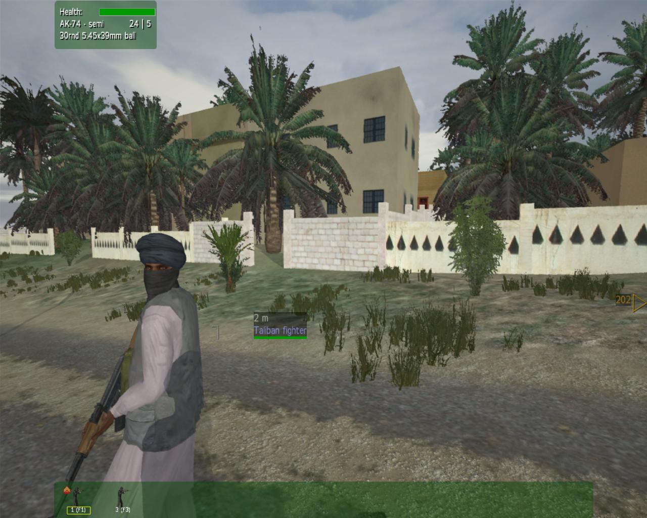
| When TerraSim Inc. brought out their TerraTools Exporter for VBS2 (see here), it was obviously important that VizMAP, as the regional distributor, hit the ground running able to use and demonstrate it. We set about exporting a variety of our existing 3D databases previously created with TerraTools into the VBS2 format, then running around them in VBS2 shooting stuff and blowing stuff up!
The TerraTools TechNote produced for the VBS2 Exporter comes with the raw data (DEM, textures, models, GIS landuse, creeks and roads, etc.) enabling the creation from scratch of "A Desert Village" which, if you follow the instructions, ends up with an exported .pbo file, packed and loaded directly into VBS2. Obviously, you need current licenses for both TerraTools and VBS2 to be able to do this. If you have a TerraTools license and want to obtain the VBS2 Export plugin, contact me here. If you are in the hunt for VBS2, go to their website here.
These screenshots are of the TerraTools exported Desert Village as seen from within the VBS2 run-time environment.
Click on these small resampled images to view the full screen images from the VizMAP website. Bear in mind that these are just screen dumps from a dynamic, interactive, 3D "flythrough".
If you would like more information on this project, or need your own similar project performed, let VizMAP know
|
| If you have a need to dynamically visualise your geographic data, let VizMAP know your requirements… |
Back to Top |
| Safari 4 Downloads Top 11 Million in Three Days |
from Apple |
| CUPERTINO, California—June 12, 2009—Apple® today announced that more than 11 million copies of Safari® 4 have been downloaded in the first three days of its release, including more than six million downloads of Safari for Windows. Safari 4 is the world’s fastest, most innovative browser and is built on the world’s most advanced browser technologies including the new Nitro JavaScript engine that executes JavaScript nearly eight times faster than IE 8 and more than four times faster than Firefox 3. Safari quickly loads HTML web pages more than three times faster than IE 8 and three times faster than Firefox 3.*
“Safari 4 is an incredible success on Mac and Windows with more than 11 million downloads in the first three days,” said Philip Schiller, Apple’s senior vice president of Worldwide Product Marketing. “Safari users love the incredible speed and innovative features like Top Sites, Full History Search and Cover Flow.”
Starting with the development of the open source WebKit browser engine, Apple has been leading the industry in defining and implementing innovative web standards. Safari 4 includes HTML 5 support for offline technologies and support for advanced CSS Effects, enabling an entirely new class of web applications that feature rich media, graphics and fonts. Safari 4 is the first browser to pass the Web Standards Project’s Acid3 test, which examines how well a browser adheres to CSS, JavaScript, XML and SVG standards that are specifically designed for dynamic web applications.
Safari 4 includes Top Sites, for an incredible visual preview of frequently visited and favorite pages; Full History Search, to search through titles, web addresses and the complete text of recently viewed pages; and Cover Flow®, to easily flip through web history or bookmarks. Other innovative features include Smart Address Fields for automatically completing web addresses from an easy to read list of suggestions; Search Fields, to fine tune searches with recommendations from Google Suggest or a list of recent searches; and Full Page Zoom, for a closer look at any website without degrading the quality of the site’s layout and text.
In Mac OS® X Snow Leopard™, available later this year, Safari runs as a 64-bit application, boosting the performance of the Nitro JavaScript engine by up to 50 percent.** Snow Leopard makes Safari more resistant to crashes by running plug-ins in a separate process, so even if a plug-in crashes, Safari continues to run and the user simply has to reload the affected page. Safari running on Snow Leopard also delivers HTTP streaming, making it easy to deliver high-quality audio and video in industry standard formats from any web server without the need for browser plug-ins. |
| Read that full story here |
Back to Top |
Whazzup Next –
with 20/20 Foresight… |
| Check these sites for events to look out for in the Vis/Sim, GIS, LIS, Remote Sensing & Photogrammetry calendars… |
|
| |
Back to Top |
A Parting
Gesture… |
The Monastery
|
From Grime |
| A man is driving down a country road in Ireland and his car breaks down near a monastery. He goes to the monastery, knocks on the door, and says, "My car broke down. Do you think I could stay the night?" The Monks graciously accept him, feed him dinner, show him to a room, and even fix his car.
As the man tries to fall asleep, he hears a strange sound. A sound not like anything he’s ever heard before. It is the most beautiful sound he has ever heard in his life. He is instantly captivated and enchanted. The Sirens that nearly seduced Odysseus into crashing his ship comes to his mind. He doesn’t sleep that night. He tosses and turns trying to figure out what could possibly be making such a hauntingly seductive sound.
The next morning, he asks the Monks what the sound was, but they say, "We can’t tell you. You’re not a Monk."
Distraught, the man is forced to leave.
Years later, after never being able to forget that sound which continually echoes in his mind, the man goes back to the monastery and pleads for the answer again. The Monks reply, "We can’t tell you. You’re not a Monk." The man says, "If the only way I can find out what is making that beautiful sound is to become a Monk, then please, make me a Monk." The Monks reply, "You must travel the earth and tell us how many blades of grass there are and the exact number of grains of sand. When you find the answer to these questions, you will have become a Monk."
The man sets about his task.
After years of searching he returns as a grey-haired old man and knocks on the door of the monastery. A Monk answers. He is taken before a gathering of all the Monks. "In my quest to find what makes that beautiful sound, I travelled the earth and have found what you asked for: By design, the world is in a state of perpetual change. Only God knows what you ask. All a man can know is himself, and only then if he is honest and reflective and willing to strip away self deception."
The Monks reply, "Congratulations. You have become a Monk. We shall now show you the way to the mystery of the sacred sound."
The Monks lead the man to a wooden door, where the head monk says, "The sound is beyond that door."
The Monks give him the key, and he opens the door.
Behind the wooden door is another door made of stone. The man is given the key to the stone door and he opens it, only to find a door made of ruby. And so it went that he needed keys to doors of emerald, pearl and diamond. Finally, they come to a door made of solid gold.
The sound has now become very clear and definite.
The Monks say, "This is the last key to the last door." The man is apprehensive to no end. His life’s wish is behind that door! With trembling hands, he unlocks the door, turns the knob, and slowly pushes the door open. Falling to his knees, he is utterly amazed to discover the source of that haunting and seductive sound…..
But I cannot tell you what it is because you’re not a Monk. |
|
Back to Top |
|
VizMAP
Letting you see where you stand…
Feel free to forward this to whomsoever you wish.
To e-mail the VirtualGeography Editor, click here.
To subscribe to VirtualGeography, click here.
To unsubscribe from VirtualGeography, click here.
|
| |
…that’s all, folks. For now…
|
|
VizMAP
- Bureau & Services Portfolio
- Contact Us
- News
- Gladstone Port Access Road nearly complete after VizMAP visualisation convinces Council
- TerraTools Exporter for Virtual Battlespace 2 (VBS2) Now Available – 23/3/9
- Updated interactive “Flash Map” of Advanced Mining Projects in Queensland by VizMAP to be distributed to delegates of Mining 2006
- VizMAP & E2E deliver workshop at Queensland Spatial Conference, Brisbane, Queensland – 17/7/8
- VizMAP creates “virtual trek” to the Everest Base Camp
- VizMAP creates virtual coal mine for central Kalimantan
- VizMAP develops interactive “Flash Map” of Advanced Mining Projects in Queensland
- VizMAP imagery of Virtual Surat Energy Province awarded image of the month by Image Society Inc.
- VizMAP Launched
- VizMAP launches FlyLG: computer based geospatial Visualisation tailored to Australian local government areas
- VizMAP presents at Australia Pacific Spatial Innovation Conference 08, Canberra, ACT – 19/11/8
- VizMAP presents at GITA 07, Brisbane, Queensland – 8/8/7
- VizMAP presents at GITA Seminar, Darwin, Northern Territory – October, 2006
- VizMAP presents at Queensland Spatial Conference 2008, Brisbane, Queensland – 18/7/8
- VizMAP presents at Surveying and Spatial Sciences Institute (SSSI) Meeting, Hervey Bay
- VizMAP Presents TerraTours® Visualization at World Energy Congress
- VizMAP presents to Darling Downs Interest Group in GIS and Remote Sensing (DIGGARS) Seminar, USQ, Toowoomba, Queensland – 8/11/7
- VizMAP presents to International Map Trade Association (IMTA), Surfer’s Paradise, Queensland – 2/11/7
- VizMAP presents to Queensland Spatial Industry Council (QSIC), Brisbane, Queensland – 22/11/7
- VizMAP writes for Position Magazine – “The 3D Industry” – April-May 2007, No 28
- VizMAP’s Virtual Surat Energy Province
- VirtualGeography Index
- VizMAP
|