vol 1 num 4

from VizMAP – letting you see where you stand…
Volume 1 – Number 4
|
| About VizMAP
VizMAP Pty Ltd, is a leading supplier of terrain Visualisation and related services to the defence, GIS, environmental, mapping, mining and exploration industries, engineering and construction firms, developers and planners, as well as government administration departments dealing with land, transportation and the environment.
VizMAP‘s products are designed to be run on reasonably to highly configured graphics computers (PC, Linux and Unix) for public display, group training, mission rehearsal, environmental monitoring, etc. and to enhance management decision making.
VizMAP is headquartered on Queensland’s Sunshine Coast (Australia) with affiliation in Asia, Europe, Africa and the USA and thereby provides support and services to customers worldwide.
If you need to visualise anything geographic, e-mail VizMAP here with the details.
For more information about VizMAP visit the VizMAP Web site at http://www.vizmap.com.au.
|
VirtualGeography
Subscription
Details
To subscribe to VirtualGeography,
click here.
To unsubscribe to VirtualGeography,
click here.
|
| A Moment’s Notice
To be or not to be — W. Shakespeare
To be is to do. — I. Kant
To do is to be. — A. Sartre
Do be a Do Bee! — Miss Connie, Romper Room
Do be do be do! — F. Sinatra
Yabba-Dabba-Doo! — F. Flintstone
 |
|
VirtualGeography – the newsletter
|
| G’Day… and Welcome to VirtualGeography |
from VizMAP |
| Welcome to another free VirtualGeography from VizMAP Pty Ltd.
VirtualGeography is a collection of interesting snippets from all over the shop, dealing with industry issues concerning the computer based visualisation of geography and a few other associated (or otherwise) interesting bits and pieces. You are receiving this either because you subscribed to VirtualGeography or you have had recent dealings with VizMAP Pty Ltd. If you do not wish to receive further instalments of VirtualGeography, just click on the unsubscribe link at the bottom of this e-mail.
A new VirtualGeography is pushed out about once per month, towards the end of the month, which shouldn’t be too big a drain on your mailbox if you’re not already subscribed (of course it won’t be a drain on your mailbox if you ARE subscribed, either ). If you know of anyone who might like to get VirtualGeography, feel free to forward this to them and ask them to subscribe. By the way, subscription and unsubscription details are at the bottom (click here).
So, g’day to all you enthusiasts requiring to visualise and simulate both urban and rural geographic information (GIS), cartography, photogrammetry, remote sensing, digital elevation modelling (DEM) and general mapping.
By the spelling of "Visualisation" you may have already guessed that we’re not US based – that’s a good thing, or at least not a bad thing. This comes to you from Mooloolaba on the Sunshine Coast of Queensland, Australia, where it’s beautiful one day and perfect the next.
The link between visualisation and mapping may seem a little esoteric if this is your first encounter with this sort of stuff, but let me tell you, the bond is significant… but enough of that: on with the show… I hope you like it. Any feedback you might have is highly appreciated. E-mail me hereto make your comments.
Enjoy…
Graeme Brooke
VizMAP Pty Ltd
P.S. You’ll need an active internet connection to view any images that are in the content. We’ve done it this way to keep the size of the e-mail to a minimum.
|
| |
Back to Top |
| The Industry’s Two Cents Worth… |
| SAAB AVIONICS SELECTS QUANTUM3D FOR SWEDISH HKP14 HELICOPTER |
from Quantum3D |
| Quantum3D Sentiris PMC and Farsight nV Designs to Provide Digital Map Images and Advanced Situational Awareness Information for Swedish HKP14 Pilots
WASHINGTON, DC – October 21, 2002 – Quantum3D®, Inc., today announced at the Association of the U.S. Army (AUSA) Annual Conference in Washington, D.C., a new embedded graphics subsystems design win with Saab Avionics AB for the Swedish multi-role helicopter, HKP14. Under the terms of its contract, Quantum3D will provide Saab Avionics with Sentiris(tm) PCI Mezzanine Cards (PMCs) to drive the helicopter’s digital map system, and develop a custom video/graphics subsystem to power the helicopter’s displays for advanced situational awareness information. The Sentiris PMC and other Quantum3D visual computing products and solutions will be on demonstrated in booth 729 at AUSA.
This program marks the first major avionics program win for the Sentiris PMC COTS 2D/3D embedded graphics subsystem, and another major win for Quantum3D’s Farsight nV(tm) program-the Quantum3D and NVIDIA® initiative under which Quantum3D brings NVIDIA graphics technology to the embedded visual computing market. Under the Farsight nV program, Quantum3D provides commercial and military aircraft, vehicles, vessels and transportable systems integrators and manufacturers with Quantum3D developed graphics subsystems based on NVIDIA Quadro®4 Graphics Processing Units (GPUs) for realtime graphical, sensor, symbolic and imagery-based information systems used by air, ground vehicle and vessel crews to provide enhanced situational awareness and operational mission effectiveness.
"This win further demonstrates the momentum of the Farsight nV program, and shows the versatility of our efforts with NVIDIA to deploy both custom and COTS (Sentiris PMC) designs into leading edge systems like the Swedish HKP14," said Ross Q. Smith, Quantum3D co-founder and executive vice president marketing and business development. "Saab Avionics will benefit from our NVIDIA-based graphics technology across their entire product line by its ability to provide their customers with unmatched graphics performance and enhanced capabilities."
|
| Read that full story here |
Back to Top |
| Hardcore Stuff (hardware bits)… |
| Quantum3D Announces Independence – The First 4th Gereation, Open Architecture Image Generator with Enterprise Class Computing Features |
from Quantum3D |
| U.S. Army’s CH-47F Transportable Flight Proficiency Simulator Marks First Independence Program Win
SAN JOSE, CA – October 17th, 2002 – Quantum3D®, Inc., a leading provider of open architecture realtime 3D visual computing platforms and solutions for the Visual Simulation and Training (VST) and Embedded Visual Computing (EVC) markets, today announced Independence(tm), the first 4th generation Image Generator (IG). Independence’s 4th generation design employs a unique "system level" implementation of Quantum3D’s Parallel Rendering Architecture (PRA(tm)) that provides industry leading realtime performance, unmatched full scene anti-aliased (FSAA) image quality and essential features that far exceed the capabilities of competitive IGs – all while preserving the open architecture and value proposition benefits that are the hallmark of Quantum3D products.
Independence is also the first IG to feature "enterprise class" computing capabilities including "four-nines" high availability, Intrinsic Pre-Planned Product Improvement (IP3I) and comprehensive IG Management software (IGM(tm))-all of which are designed to ensure longevity of the system and reduce the user’s total cost of ownership. IGM is a comprehensive suite of system administration tools that greatly simplify IG configuration management, housekeeping and runtime management tasks via an intuitive graphical user interface. IGM provides hierarchical access and control of the IG- including all of the system’s scalable performance and image quality features. Independence’s 4th generation design uniquely supports IP3I by accommodating the ready insertion of new technology at the subsystem level. Independence’s IP3I capability addresses technology obsolescence issues that confront other IGs by enabling continuous performance and feature improvement over the life of the system. Independence is also the first IG to achieve 0.9999 ("four nines") effective availability. Independence’s high availability, which enables the system to continue operating after subsystem failures, results in significantly reduced IG downtime-typically by a factor of ten, when compared with 3rd generation or proprietary IGs.
|
| Read that full story here |
Back to Top |
| SGI Demonstrates Innovative Visual Area Networking and Visualization Technologies |
from SGI |
| Latest Visualization Technology Developments in Manufacturing and Energy Showcased in Genoa, Italy
MOUNTAIN VIEW, Calif. (October 23, 2002)-SGI (NYSE: SGI) will be showcasing advances in collaborative visualization technology and Visual Area Networking for the manufacturing and oil and gas industries at an SGI VizSummit being held in Genoa, Italy, today through Friday, October 23-25. Representatives of leading international industrial and energy companies will be among the key speakers at the event, discussing their innovative uses of SGI® visualization technologies as business tools.
The summit brings together industry leaders who are using the latest collaborative visualization technologies to move boundaries within their fields of expertise. Techniques demonstrated and discussed include the use of immersive visualization in the styling development process, real-time analysis of large 3D seismic data and the application of visual networks to transform the future of design.
The concept of Visual Area Networking, introduced by SGI, enables universal access to advanced visualization using any computing device over standard networks. It allows scientists and engineers to store and process data in one place; this data can then be accessed and manipulated by customers using any client device, either singly or collaboratively across existing networks. It puts high-performance computing power in the hands of scientists, engineers and creative professionals, no matter where they are located.
"For this event, we have brought together a unique mix of customers, end users and technology partners within the manufacturing and energy markets to share and develop new innovations in high-performance visualization," commented SGI’s Steve Coggins, senior vice president, Europe, Middle East and Africa.
"Through live demonstrations and discussion groups, we will be showing organizations how they can easily adopt cutting-edge visualization technologies as business tools to build better cars or drill for oil," he added. "Visualization technology is evolving at a rapid pace, and SGI will show how it continues to be at the cutting edge, including presentations around new developments in Visual Area Networking."
|
| Read that full story here |
Back to Top |
| Softcore Stuff (software and data bits)… |
| The Virtual Terrain Project |
from VTP |
The goal of VTP is to foster the creation of tools for easily constructing any part of the real world in interactive, 3D digital form.
This goal will require a synergetic convergence of the fields of CAD, GIS, visual simulation, surveying and remote sensing. VTP gathers information and tracks progress in areas such as procedural scene construction, feature extraction, and rendering algorithms. VTP writes and supports a set of software tools (VTP Toolbox) and an interactive runtime environment (VTP Enviro). The tools and their source code are freely shared to help accelerate the adoption and development of the necessary technologies.
"Imagine being able to walk down the streets of Paris, seeing the sights and hearing the sounds around you, without leaving your home. You are able to converse with a friend who is also online, and the two of you decide to fly to Tahiti together. As you travel around the globe, you stop momentarily at places of interest to view three-dimensional (3D) representations of local structures, learn about representative works of art, browse historical information for the area, or view real-time video and audio feeds of local events. Apart from its entertainment value, the educational, environmental, and societal benefits of such a facility are enormous."
|
| Read that full story here |
Back to Top |
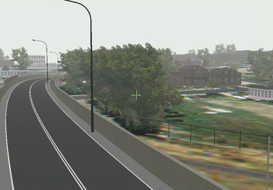
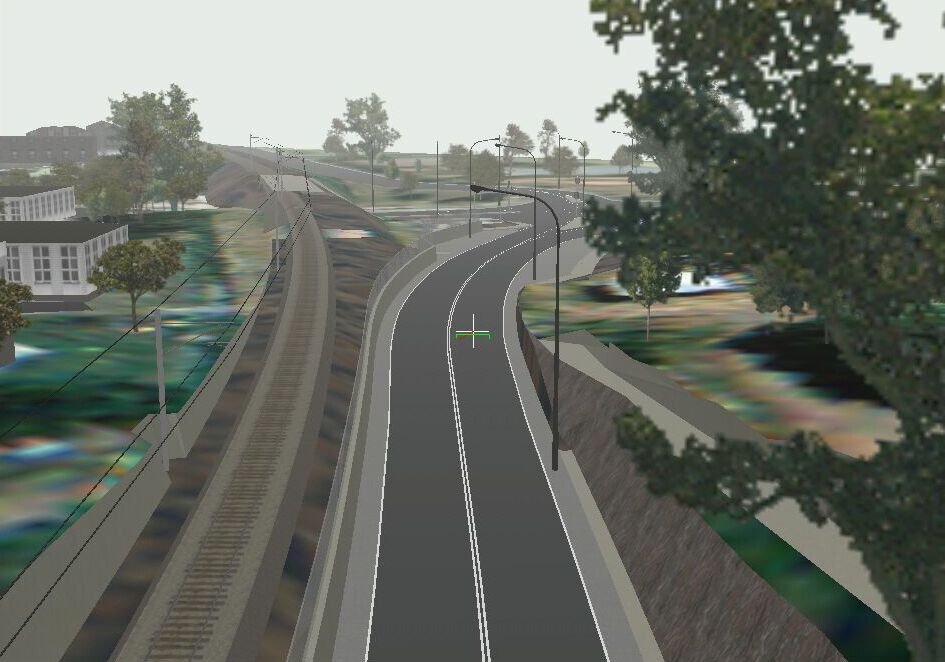
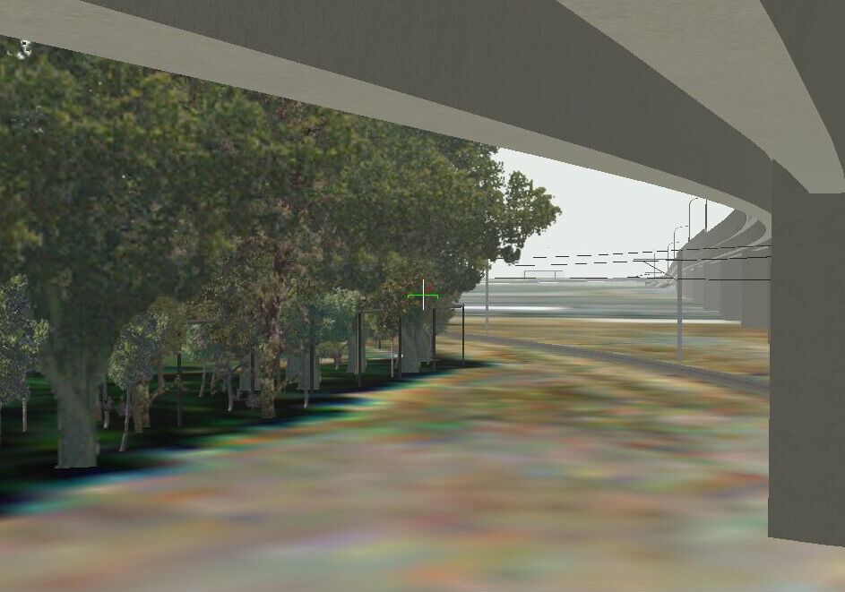
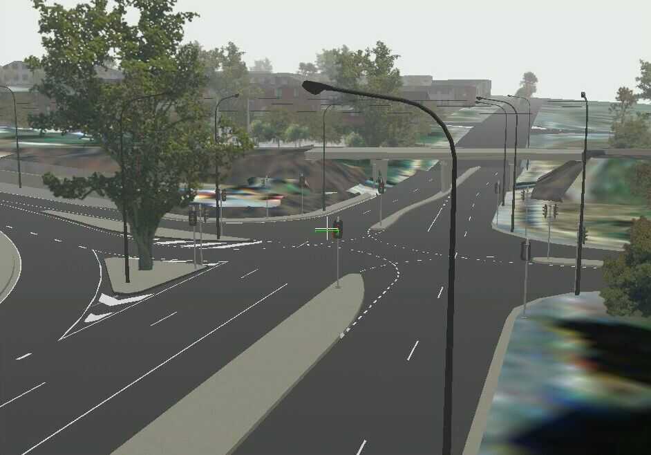
| Queensland’s Department of Main Roads |
from VizMAP |
| VizMAP was recently contracted by the Department of Main Roads in Queensland to construct a Vis/Sim database for a proposed regional city bypass including an overpass and electric rail.
Sample still images from the completed dynamic visualisation database are displayed here. An active internet connection is required to be able to view these scenes.
Click on these small resampled images to view the full screen images on the VizMAP website. Bear in mind that these are just screen dumps from a dynamic, interactive, 3D "flythrough".
|
| If you have a need to dynamically visualise your geographic data, let VizMAP knowyour requirements… |
Back to Top |
| Geography Matters |
from GIS Day |
| There is a basic ingredient for significantly improving decision making that involves the location, distribution, or impact of people, places, and events in the world. Proximity of customers to a store location, the routing of emergency vehicles to an incident, and the change over time in a habitat all share the common component of geography.
Just about anyone or anything can be associated with a known location in the world…a street address, a service region, a climatic zone, a voting district, a latitude/longitude coordinate. Geographic information systems (GIS) software is the ideal tool for extracting the patterns and trends inherent in location-based information.
Mapmaking and geographic analysis are not new, but a GIS performs these tasks better and faster than do the old manual methods. And, before GIS technology, only a few people had the skills necessary to use geographic information to help with decision making and problem solving.
Today, GIS is a multibillion-dollar industry employing hundreds of thousands of people worldwide. GIS is taught in schools, colleges, and universities throughout the world. Professionals in every field are increasingly aware of the advantages of thinking and working geographically.
|
| Read that full story here |
Back to Top |
| Whazzup Next – with 20/20 Foresight… |
Stuff to look out for in November, December & January
| Legend |
| Included in last issue… |
| Updated since last issue… |
| New since last issue… |
|
This calendar of events has been collated from:
|
| November, 2002 |
| 29 October – 1 November, 2002 |
OSEA2002 |
Suntec, Singapore |
| 1 November |
Newtech Conference |
Ballarat, Vic. Australia |
| 11/1/2002 |
Assessing Current and Future Needs for Positioning Control for Geospatial Activities in Louisiana |
New Orelans, LA USA |
| November 3 – 6, 2002 |
The Northeast ARC User Group |
Bretton Woods, New Hampshire USA |
| 11/3/2002 – 11/8/2002 |
ESRI Southeast Regional User Group Meeting |
Chattanooga, TN USA |
| 4-5 November |
Bentley Geoengineering Summit |
Madrid, Spain |
| 11/4/2002 – 11/5/2002 |
Annual Conference of the Illinois Geographic Information Systems Association |
Lisle, Illinois USA |
| November 5 – 7, 2002 |
Virginia Water Research Symposium |
Richmond, VA USA |
| 6 November |
Historical Outlook: Introduction to Historical Imagery |
Birmingham, UK |
| 11/6/2002 – 11/7/2002 |
Telematics West 2002: Safety and Security |
San Diego, CA |
| November 6-8, 2002 |
Energy Information Technology Conference & Expo |
Las Vegas USA |
| November 6-9, 2002 |
2002 Bentley Developer Conference |
Madrid, Spain |
| 11/7/2002 |
2002 Virginia Crime Analysis Vendor Fair |
Chesterfield, VA USA |
| 7-8 November |
Space Information Symposium – Technologies, Acquisition, Processing & Effective Application |
Sofia, BULGARIA |
| 8-9 November |
ACM-GIS 2002 Call for Paper – The 10th ACM International Symposium on Advances in GIS |
McLean, VA USA |
| 8-15 November |
15th William T. Pecora Memorial Remote Sensing Symposium/Land Satellite Information IV Conference and Exhibition jointly with the ISPRS Commission I (Platforms & Sensors) Symposium |
Denver, Colorado USA |
| November 10 – 11, 2002 |
Virginia Association of Counties (VACO) |
Bath County, VA USA |
| 11-15 Nov 2002 |
UN Regional Workshop on the Use of Space Technology for Disaster Management for Asia and the Pacific |
Bangkok, THAILAND |
| 11-15 Nov 2002 |
Symposium of Commission I, Joint meeting with Pecora XV |
Denver, Colorado USA |
| November 12, 2002 |
DMTI Spatial Product Insight Seminars |
Markham, Ontario, Canada |
| November 12-14, 2002 |
EnTech West ’02 – Environmental Management & Technology Conference and Exhibition |
Long Beach, CA USA |
| 11/12/2002 – 11/14/2002 |
GTC Southeast 2002 |
Atlanta, GA USA |
| 12-15 November 2002 |
NAVSAT 2002 – The Satellite Navigation and Positioning World Show |
Nice-Acropolis, France |
| November 13 – 14, 2002 |
Geospatial Intelligence Conference: The Association of Old Crows and the National Imagery and Mapping Agency (NIMA) |
Chantilly, VA USA |
| November 13-15, 2002 |
Municipal Software’s 2002 CityView User Conference |
Chicago USA |
| 11/13/2002 – 11/16/2002 |
NovaLIS User Conference"Coming Together" |
Daytona, FL USA |
| November 14-15, 2002 |
The 1st Annual North Florida GIS Conference |
Tallahassee/Big Bend, FL USA |
| 14-16 November |
International Map Trade Association Conference |
Wellington; New Zealand |
| 11/14/2002 – 11/19/2002 |
MapWorld User Conference 2002 |
San Diego, CA USA |
| Nov 15-20, 2002 |
MapInfo User Week |
San Diego, California USA |
| 11/16/2002 – 11/20/2002 |
CoreNet Global Summit |
San Diego, CA USA |
| 11/18/2002 – 11/19/2002 |
Insurance Exit Strategies |
London, UK |
| 18-22 Nov 2002 |
International Conference on Fuzzy Systems and Knowledge Discovery (FSKD’02) |
SINGAPORE |
| 18-22 Nov 2002 |
9th International Conference on Neural Information Processing (ICONIP’02) |
SINGAPORE |
| 18-22 Nov 2002 |
4th Asia-Pacific Conference on Simulated Evolution And Learning (SEAL’02) |
SINGAPORE |
| 18th to 22nd November 2002 |
GIS in Telecoms |
Las Vegas, NV USA |
| November 19, 2002 |
DMTI Spatial Product Insight Seminars |
Markham, Ontario, Canada |
| 11/19/2002 – 11/20/2002 |
Regulation of General Insurance Intermediaries |
London, UK |
| 19th – 21st November 2002 |
IIR’s European LBS Forum |
Nice, France |
| 20 November |
GIS Day 2002 |
Worldwide |
| 24-27 November |
22nd Annual ALGIM (Association of Local Government Information Management) Conference |
Taupo, NZ |
| 11/25/2002 – 11/26/2002 |
Reinsurance Dispute Resolution |
London, UK |
| 25-29 Nov 2002 |
23rd ACRS of AARS, "ACRS 2002" |
Kathmandu, NEPAL |
| 25-30 November |
e-future: into the mainstream; AURISA/ISA Joint 2002 Conference (bringing together AURISA 2002 and 3rd Trans Tasman Surveyors Conferences) |
Adelaide, South Australia |
| November 26, 2002 |
DMTI Spatial Product Insight Seminars |
Markham, Ontario, Canada |
| December, 2002 |
| 12/2/2002 – 12/3/2002 |
Loan Workouts |
London, UK |
| December 3, 2002 |
GITA Webcast: CIS/GIS/CRM – Maximizing your Customer Information with Integration to GIS |
USA |
| December 3, 2002 |
DMTI Spatial Product Insight Seminars |
Markham, Ontario, Canada |
| 12/3/2002 – 12/4/2002 |
7th Polish Bank Congress |
Warsaw, Poland |
| 3-5 December |
SIRC 2002 – ‘Physical and Cognitive Spaces’: 14th Annual Colloquium of the Spatial Information Research Centre |
Wellington, NZ |
| 3-5 December |
Geobroadcasting 2002 |
Quebec City, Quebec Canada |
| 3-6 December |
ISPRS International Symposium on Resource and Environmental Monitoring |
Hyderabad, India |
| 3-6 December |
Autodesk University 2002 |
Las Vegas, Nevada USA |
| 12/5/2002 – 12/6/2002 |
Advanced Technology Licensing |
London, UK |
| 7-11 Dec 2002 |
ISPRS The Council and Joint Meetings with Technical Commission Presidents |
Hyderabad, India |
| 8-11 Dec 2002 |
Sixth Annual International Crime Mapping Research Conference |
Denver, Colorado USA |
| 11-12 December |
Third Annual Geographic Imagery User Group Meeting |
Cambridge, UK |
| 12 December |
Second International Workshop on Web and Wireless GIS 2002 |
Singapore |
| 12 December |
WISE 2002 – 3rd International Conference on Web Information Systems Engineering |
Singapore |
| January, 2003 |
| 6-9 Jan 2003 |
Coastal GeoTools ’03 |
Charleston, South Carolina USA |
| 7-10 Jan 2003 |
PIERS 2003 Progress in Electromagnetics Research Symposium |
Singapore |
| 1/12/2003 – 1/15/2003 |
National Retail Federation Annual Convention & Expo |
New York, NY USA |
| 1/14/2003 |
Product Insight Seminar – Census Demographic Products |
Markham, Ontario Canada |
| 20-24 Jan 2003 |
Workshop of ISPRS WG V/2 "Videometrics VIII" IS&T/SPIE’s Symposium Electronics Imaging Science & Technology |
St.Clara, California USA |
| January 21-23, 2003 |
WIRELESS POSITIONING & LBS 2003 |
San Francisco, California USA |
| 1/22/2003 – 1/24/2003 |
National Technical Meeting – The Institute of Navigation (ION) – 2003 |
Anaheim, CA USA |
| 1/27/2003 – 1/28/2003 |
Voice-Activated Services Summit |
London, UK |
| 27-29 Jan 2003 |
10th international conference GIS "GIS Ostrava 2003" |
Ostrava, Czech Republic |
| 28-31 January 2003 |
Map India 2003 |
New Delhi, India |
| January 29-31, 2003 |
Miner & Miner User Group Meeting (MMUG) |
Ft. Collins, Colorado USA |
|
| |
Back to Top |
| The River |
Very loosely "geographic" in nature from Giggleville (slightly amended) |
| One day, three men were hiking and unexpectedly came upon a large raging, violent river. They needed to get to the other side, but had no idea of how to do so. The first man prayed to God, saying, "Please God, give me the strength to cross this river." POOF! God gave him big arms and strong legs, and he was able to swim across the river in about two hours, after almost drowning a couple of times.
Seeing this, the second man prayed to God, saying, "Please God, give me the strength …and the tools to cross this river." POOF! God gave him a rowboat and he was able to row across the river in about an hour, after almost capsizing the boat a couple of times.
The third man had seen how this worked out for the other two, so he also prayed to God saying, "Please God, give me the strength and the tools…and the intelligence…to cross this river."
And POOF! God turned him into a geographer. He looked at the map, hiked upstream a couple of hundred metres, then walked across the bridge.
|
|
Back to Top |

Feel free to forward this to whomsoever you wish.
To e-mail the VirtualGeography Editor, click here.
To subscribe to VirtualGeography, click here.
To unsubscribe to VirtualGeography, click here.
…that’s all, folks! (for now).
|
|
VizMAP
- Bureau & Services Portfolio
- Contact Us
- News
- Gladstone Port Access Road nearly complete after VizMAP visualisation convinces Council
- TerraTools Exporter for Virtual Battlespace 2 (VBS2) Now Available – 23/3/9
- Updated interactive “Flash Map” of Advanced Mining Projects in Queensland by VizMAP to be distributed to delegates of Mining 2006
- VizMAP & E2E deliver workshop at Queensland Spatial Conference, Brisbane, Queensland – 17/7/8
- VizMAP creates “virtual trek” to the Everest Base Camp
- VizMAP creates virtual coal mine for central Kalimantan
- VizMAP develops interactive “Flash Map” of Advanced Mining Projects in Queensland
- VizMAP imagery of Virtual Surat Energy Province awarded image of the month by Image Society Inc.
- VizMAP Launched
- VizMAP launches FlyLG: computer based geospatial Visualisation tailored to Australian local government areas
- VizMAP presents at Australia Pacific Spatial Innovation Conference 08, Canberra, ACT – 19/11/8
- VizMAP presents at GITA 07, Brisbane, Queensland – 8/8/7
- VizMAP presents at GITA Seminar, Darwin, Northern Territory – October, 2006
- VizMAP presents at Queensland Spatial Conference 2008, Brisbane, Queensland – 18/7/8
- VizMAP presents at Surveying and Spatial Sciences Institute (SSSI) Meeting, Hervey Bay
- VizMAP Presents TerraTours® Visualization at World Energy Congress
- VizMAP presents to Darling Downs Interest Group in GIS and Remote Sensing (DIGGARS) Seminar, USQ, Toowoomba, Queensland – 8/11/7
- VizMAP presents to International Map Trade Association (IMTA), Surfer’s Paradise, Queensland – 2/11/7
- VizMAP presents to Queensland Spatial Industry Council (QSIC), Brisbane, Queensland – 22/11/7
- VizMAP writes for Position Magazine – “The 3D Industry” – April-May 2007, No 28
- VizMAP’s Virtual Surat Energy Province
- VirtualGeography Index
- VizMAP
|