vol 2 num 6

from VizMAP – letting you see where you stand…
Volume 2 – Number 6
|
| About VizMAP
VizMAP Pty Ltd, is a leading supplier of terrain Visualisation and related services to the defence, GIS, environmental, mapping, mining and exploration industries, engineering and construction firms, developers and planners, as well as government administration departments dealing with land, transportation and the environment.
VizMAP‘s products are designed to be run on reasonably to highly configured graphics computers (PC, Linux and Unix) for public display, group training, mission rehearsal, environmental monitoring, etc. and to enhance management decision making.
VizMAP is headquartered on Queensland’s Sunshine Coast (Australia) with affiliation in Asia, Europe, Africa and the USA and thereby provides support and services to customers worldwide.
If you need to visualise anything geographic, e-mail VizMAP here with the details.
For more information about VizMAP visit the VizMAP Web site at http://www.vizmap.com.au.
|
VirtualGeography
Subscription
Details
To subscribe to VirtualGeography,
click here.
To unsubscribe to VirtualGeography,
click here.
|
A Moment’s Notice
"My dog is worried about the economy because Alpo is up to $3.00 a can. That’s almost $21.00 in dog money." — Joe Weinstein  |
|
VirtualGeography – the newsletter
|
| G’Day… and Welcome to VirtualGeography |
from VizMAP |
| Welcome to free VirtualGeography from VizMAP Pty Ltd.
I have to apologise again that this one is a little late but I’m still currently on a Land Administration assignment in the Solomon Islands and my available time after hours to prepare the VG limited.
VirtualGeography is a collection of interesting snippets from all over the shop, dealing with industry issues concerning the computer based visualisation of geography and a few other associated (or otherwise) interesting bits and pieces. You are receiving this either because you subscribed to VirtualGeography or you have had recent dealings with VizMAP Pty Ltd. If you do not wish to receive further instalments of VirtualGeography, just click on the unsubscribe link at the bottom of this e-mail.
A new VirtualGeography is pushed out about once per month, towards the end of the month, which shouldn’t be too big a drain on your mailbox if you’re not already subscribed (of course it won’t be a drain on your mailbox if you ARE subscribed, either ). If you know of anyone who might like to get VirtualGeography, feel free to forward this to them and ask them to subscribe. By the way, subscription and unsubscription details are at the bottom (click here).
So, g’day to all you enthusiasts requiring to visualise and simulate both urban and rural geographic information (GIS), cartography, photogrammetry, remote sensing, digital elevation modelling (DEM) and general mapping.
|
By the spelling of "Visualisation" you may have already guessed that we’re not US based – that’s a good thing, or at least not a bad thing. This comes to you from Mooloolaba on the Sunshine Coast of Queensland, Australia, where it’s beautiful one day and perfect the next.
The link between visualisation and mapping may seem a little esoteric if this is your first encounter with this sort of stuff, but let me tell you, the bond is significant… but enough of that: on with the show… I hope you like it. Any feedback you might have is highly appreciated. E-mail me hereto make your comments.
Enjoy…
Graeme Brooke
VizMAP Pty Ltd
|
 |
P.S. You’ll need an active internet connection to view any images that are in the content. We’ve done it this way to keep the size of the e-mail to a minimum.
|
| |
Back to Top |
| The Industry’s Two Cents Worth… |
| Space Imaging Reacts to New White House Remote-Sensing Policy |
from Space Imaging |
| Space Imaging reacted today to the President’s newly released White House policy titled U.S. Commercial Remote Sensing Space Policy (http://www.ostp.gov/html/new.html). The policy concerns the commercial remote sensing industry and the (US) government’s commitment to it. The Bush Administration’s new directive, under interagency review for a year, was announced by the White House on May 13, 2003. The directive strengthens the government’s long-term objective to establish domestic high-resolution satellite imagery companies as world industry leaders and states that it is in the national security interest to have a strong and competitive commercial remote sensing industry anchored on U.S. shores.
Delivering a keynote address at a U.S. Government-sponsored conference on commercial remote sensing in Washington, D.C. today, Secretary of Commerce Don Evans said, “The remote sensing industry is poised for great market penetration. At our department, we recognize the promise of the remote sensing industry.” During Operation Iraqi Freedom the industry “provided timely and accurate information.” said Secretary Evans.
|
| Read that full story here |
Back to Top |
| Hardcore Stuff (hardware bits)… |
| The Future of 3D Graphics |
from ExtremeTech |
| David Kirk is one of the brightest and most influential graphics architects in the world, and as last year’s recipient of Siggraph’s annual Computer Graphics Achievement Award, he stands among such graphics luminaries as Jim Blinn, Alvy Ray Smith, Kurt Akeley, and John Warnock. In fact, many of the world’s leading graphics architects now work for Dave either full-time or part-time at Nvidia. So when David Kirk speaks about the future of graphics, people listen. Unfortunately, Microsoft forgot to list Dave’s session in the main WinHEC conference "agenda-at-a-glance" handouts, which most attendees refer, and therefore only about 30 people attended the session in a room capable of holding about 250 people, that would otherwise have been packed.
To begin, Kirk mentioned that looking 10 years out is a long time in the graphics business, and he reflected back 10 years to the Silicon Graphics Reality Engine just emerging, and Nvidia just starting up. Looking back another 10 years to 1983, 3D graphics was in its infancy– Silicon Graphics was just created, and there were no PC graphical interfaces or operating systems (though the original Apple Macintosh would soon surface in January 1984).
Kirk rhetorically asked if we’ll be able to continue to pace of innovation in graphics over the next 10 years, similar to what we’ve seen in the past 10-15 years, where graphics performance has increased greater than a factor of two every year. Such growth rate is faster than the rate specified by Moore’s Law, where CPU processing power and/or transistor density doubles every 18 months on average. It turns out that actual silicon technology improves at a faster rate than Moore’s Law. When you account for both shrinking transistor size and faster switching speeds, you get more than 2X improvement in just under one year per Kirk. GPUs also accelerate in processing power faster than CPUs, because graphics is an "embarrassingly parallel" problem with a lot of stream processing, and there’s always as much work to be done as you can build processing power to handle it. As long as graphics chip architectures aren’t somehow hobbled, preventing access to the parallelism, or hiding it, Kirk estimates the same 2X per year performance growth rate can continue for the foreseeable future.
|
| Read that full story here |
Back to Top |
| Softcore Stuff (software and data bits)… |
| TGS, Inc. Releases Open Inventor 4.0 |
from VRSource |
| TGS, Inc. is proud to announce the availability of its Version 4.0 of Open Inventor™. With this version of Open Inventor, TGS has taken customer-inspired enhancements and broadened both the functionality and flexibility of the Open Inventor toolkit. Open Inventor dramatically simplifies the design, development, deployment, and maintenance of scalable and interactive 3D applications and has become the de facto standard for development of cross-platform (Windows®, UNIX®, Linux®) 3D graphics applications in C++ and Java™. It is a powerful object-oriented toolkit with over 1,000 classes and an intuitive and easy-to-use programming interface that allows for rapid prototyping and development of graphics applications.
Major enhancements in version 4.0 include: Native SoQt Library, Multi-Volume Support, Volume Geometry Nodes, Expanded Display Support, Bump Mapping Support, Improved Transparency, and much more.
|
| Read that full story here |
Back to Top |
| Brisbane |
from VizMAP |
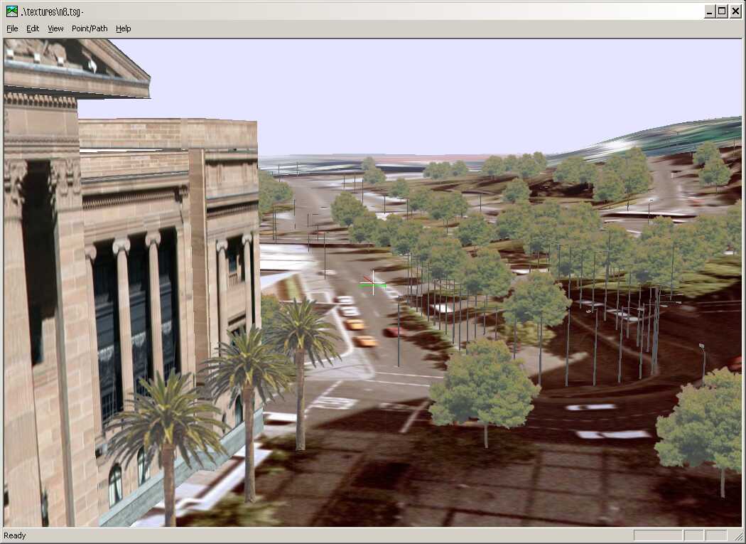
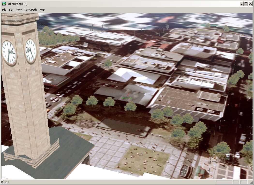
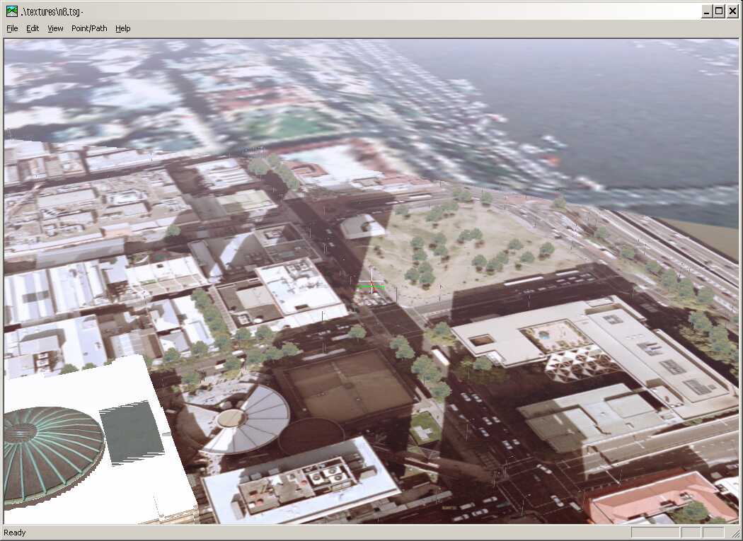
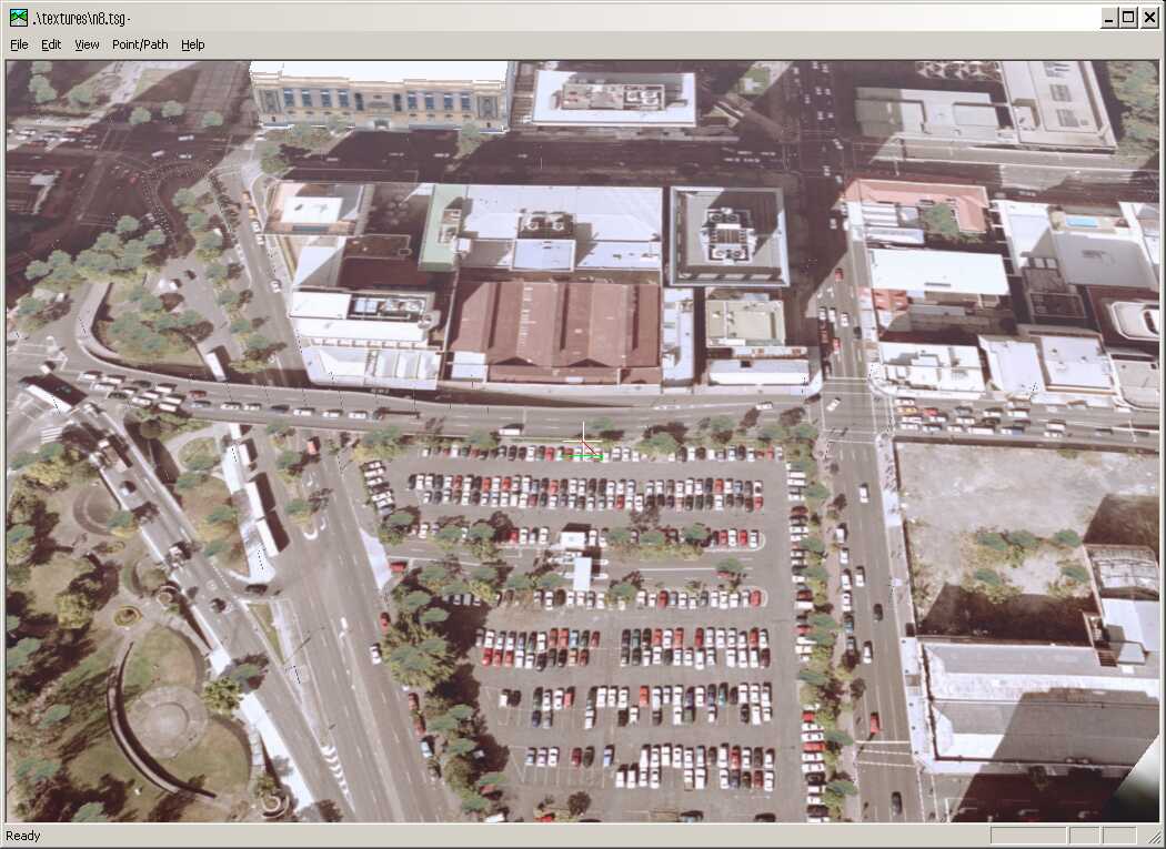
| VizMAP created a vis/sim database over Brisbane using DEM and orthoimagery from Brisbane City Council.
Sample still images from the completed dynamic visualisation database are displayed here. An active internet connection is required to be able to view these scenes.
Click on these small resampled images to view the full screen images on the VizMAP website. Bear in mind that these are just screen dumps from a dynamic, interactive, 3D "flythrough".
|
| If you have a need to dynamically visualise your geographic data, let VizMAP knowyour requirements… |
Back to Top |
| Why Geography Matters in Marketing Strategy – The Spatial Dimension to Customer Communications and Marketing |
from DirectionsMag |
| I am often reminded of a conversation I had many years ago with a nameless catalog manager for a major home shopping catalog back in the UK. It was in the mid-to-later 1990’s and the internet boom was just beginning. I spent some time explaining how useful geo-demographic segmentation would be in predicting the likelihood of their customers to be shopping online in the future, and as I got towards the end of my presentation he stopped me and asked; ‘What has geography got to do with the internet?’. This question surprised me on quite a few levels, but what sticks with me today is that it showed that there was a misunderstanding of the role and relevance of location in helping refine and improve the marketing communications of organizations.
Since that time, I have seen that kind of compartmental thinking prevalent in a number of situations. It’s almost as if many business practitioners, including the direct marketers, the internet marketers and so forth do not see the part physical geographical location has to play in their business strategy. However, before I continue, I have seen many great utilizations of spatial information, so it’s not all bad, but I do believe that through the understanding of the utility of location and the application of a few simple concepts we could see noticeable improvement in performance across a wide variety of scenarios.
What I want to do in this article is outline some reasons why spatial information and location can be highly useful in a wide number of situations. The examples I have used primarily come from the retail or business-to-consumer world, but the concepts are equally applicable to other situations.
|
| Read that full story here |
Back to Top |
| Whazzup Next – with 20/20 Foresight… |
Stuff to look out for in June, July & August
| Legend |
| Included in last issue… |
| Updated since last issue… |
| New since last issue… |
|
This calendar of events has been collated from:
|
| June 2003 |
| 2-3 Jun 2003 |
TUGIS 2003, the 16th Annual GIS Conference |
Baltimore, MD USA |
| 2-5 Jun 2003 |
23rd EARSeL Annual Symposium "Remote Sensing in Transition" |
Gent, Belgium |
| 2-5 Jun 2003 |
AEC Systems 2003 |
Washington, USA |
| 2-6 Jun 2003 |
International Symposium on Spectral Sensing Research (ISSSR 2003) ISPRS WG VII/1 |
Santa Barbara, CA, USA |
| 2-6 Jun 2003 |
ISSRM 2004 (International Symposium of Society and Resource Management) 2004 |
Keystone Resort, Colorado USA |
| 2-6 Jun 2003 |
EARSEL Symposium |
Gent, Belgium |
| 6-7 Jun 2003 |
EARSeL Workshops – "Forest Fires and Coastal Zones" |
Gent, Belgium |
| 3 Jun 2003 |
GITA Webinar… Geospatial Information: Government and Municipal Perspectives |
WWW |
| 3-6 Jun 2003 |
ISPRS WG IV/8 Workshop "Global Environmental Databases: Adaptation to Meet Current & Future Needs" |
Bangkok, Thailand |
| 4-6 Jun 2003 |
ScanGIS’2003 – The 9th Scandinavian Research Conference on Geographic Information Science |
Espoo, Finland |
| 5 Jun 2003 |
SmartTalk Events |
USA (internet) |
| 5-6 Jun 2003 |
Emerging Technology Summit II: Spatial Web Services |
Vienna, Virginia USA |
| 6-7 Jun 2003 |
EARSeL Workshops "Forest Fires and Coastal Zones" |
Gent Belgium |
| 6-7 Jun 2003 |
MapServer User Meeting |
St. Paul, Minnesota, USA |
| 9-12 Jun 2003 |
e-Gov 2003 |
Washington, DC USA |
| 9-13 Jun 2003 |
SGEM 2003 – Surveying, Geology and Environmental Management |
Albena, Bulgaria |
| 11-12 Jun 2003 |
Spatial Data Analysis Training |
Ann Arbor, Michigan USA |
| 12-13 Jun 2003 |
FME Training |
Vancouver, BC, Canada |
| 12-13 Jun 2003 |
Introduction to Boundary Analysis using BoundarySeer |
Ann Arbor, Michigan USA |
| 15-18 Jun 2003 |
IST Mobile & Wireless Communications Summit 2003 |
Aveiro, Portugal |
| 17-19 Jun 2003 |
ISPRS Joint Workshop of WG I/3 and WG II/2: Three-Dimensional Mapping from InSAR and LIDAR |
Portland, OR, USA |
| 19-20 Jun 2003 |
Spatial Futures 2003 |
Sydney, New South Wales, Australia |
| 19-20 Jun 2003 |
Status of GIS in NSW 2003 |
Sydney, New South Wales, Australia |
| 23-23 Jun 2003 |
GeoTech 2003 |
Copper Mountain, Colorado USA |
| 23-26 Jun 2003 |
The 2003 International Conference on Machine Learning;Models, Technologies and Applications (MLMTA) |
Las Vegas, Nevada, USA |
| 24-25 Jun 2003 |
Pennsylvania GIS Conference 2003 |
Harrisburg, PA USA |
| 24-27 Jun 2003 |
Space 2003-NavSat 2003 CHINA |
Geneva, Switzerland |
| 24-25 Jun 2003 |
11th Annual Pennsylvania GIS Conference |
Harrisburg, PA USA |
| 25-26 Jun 2003 |
2003 GenaWare Annual Symposium |
Durham, NC USA |
| 25-27 Jun 2003 |
The 11th International Conference on Geoinformatics’ 2003: Advanced Geoinformatics – Linking Pacific Rims to the World |
Toronto, Canada |
| 26-27 Jun 2003 |
Web-Enabled GIS Technologies Forum |
Melbourne, Victoria, Australia |
| 27 Jun 2003 |
Cumberland Group of Surveyors’ Development Seminar |
Warwick Farm, NSW, Australia |
| 27-29 Jun 2003 |
ISPRS WG VII/4 4th International Symposium "REMOTE SENSING OF URBAN AREAS 2003" |
Regensburg, Germany |
| 30 Jun – 11 Jul 2003 |
23rd IUGG General Assembly "IUGG 2003" |
Sapporo, Japan |
| July 2003 |
| 1-3 July 6-9, 2003 |
ISPRS Workshop ‘Vision Techniques for Digital Architectural and Archaeological Archives’ |
Ancona, Italy |
| 2-4 July, 2003 |
AGIT 2003 – 15th Symposium and Exposition for Applied Geoinformatics |
Salzburg, Austria |
| July 6-9, 2003 |
ESRI Education User Conference |
San Diego, California, USA |
| July, 7-8, 2003 |
Coastal GIS 2003: an integrated approach to Australian coastal issues |
Wollongong, NSW, Australia |
| July 7-11, 2003 |
International ESRI User Conference |
San Diego, California, USA |
| July 7-14, 2003 |
Tech Ed 9th Annual Summer Camp |
Bedford, New Hampshire |
| July 9-11, 2003 |
ISPRS WG II/3, IV/2 and IV/4 Joint Workshop on Advances in Spatial Data Infrastructures & Database Interoperability |
Southampton, UK |
| July 10-11, 2003 |
ISEIS 2003 Annual Conference on Systems Science and Information Technology for Environmental Applications |
Regina, CANADA |
| July 10-11, 2003 |
Avenza Systems Training |
San Diego, CA USA |
| July 10-12, 2003 |
Association of Surveyors of Papua New Guinea Conference |
Port Moresby, PNG |
| July 13-17, 2003 |
Coastal Zone 2003 |
Baltimore, Maryland, USA |
| July 13-17, 2003 |
Association of Pacific Coast Geographers, 2003 Annual Meeting |
Portland, Oregon, USA |
| July 13-19, 2003 |
SVG Open 2003 |
Vancouver, Canada |
| July 16-18, 2003 |
MultiTemp-2003: Seconde International Workshop on the Analysis of Multi-Temporal Remote Sensing Images |
Ispra (VA), Italy |
| July 16-18, 2003 |
ISPRS WG III/2 & III/8 Workshop – "From surface reconstruction to 3D scene analysis in digital imagery: theory, applications and evaluation" |
Paris, FRANCE |
| July 17-19, 2003 |
Map Asia 2003 |
Kuala Lumpur, Malaysia |
| July 17-19, 2003 |
Laser-Scan User Group 2003 Conference |
Cambridge, UK |
| July 20-22, 2003 |
2nd Annual PPGIS Conference |
Portland, OR USA |
| July 20-23, 2003 |
URISA 2nd Annual Public Participation GIS Conference (PPGIS) |
Portland State University, USA |
| July 20-24, 2003 |
GML Dev Days 2003 |
Vancouver, BC, Canada |
| July 20-25, 2003 |
Cambridge Conference 2003 – ‘National mapping – shaping the future’ |
Cambridge, Cambridgeshire, UK |
| July 21-25, 2003 |
IEEE/IGARSS 2003 International Geoscience and Remote Sensing Symposium |
Toulouse, France |
| July 22-25, 2003 |
SatNav 2003, the 6th Int’l Symp. On Satellite Navigation Technology |
Melbourne, Victoria, Australia |
| July 23-24, 2003 |
Underground Focus Live |
Manteno, Ill, USA |
| July 28-31, 2003 |
Accela Government Automation Conference |
Las Vegas, NV USA |
| 28 July – 8 August 2003 |
1st International Summer School on Geographic Information Science |
Pratolino (Tuscany) Italy |
| 28 July – 8 August 2003 |
The Vespucci Initiative – Summer School on Geographic Information Science |
Florence, Italy |
| August 2003 |
| 3 – 5 Aug 2003 |
Digital Library for Earth System Education (DLESE) Annual Meeting |
Boulder, Colorado USA |
| 5 – 8 Aug 2003 |
National Collegiate CADD Conference |
College Park, MD, USA |
| 8-10 Aug 2003 |
ISPRS IC WG II/IV 4th Joint ICA/ISPRS/EuroGeographics Workshop on Incremental Updating and Versioning of Spatial Data Bases |
Durban, South Africa |
| August 10 – 16 |
International Cartographic Conference |
Durban, South Africa |
| August 11 – 13 |
Arizona Geographic Information Council Education and Training Symposium 2003 |
Prescott, AZ USA |
| August 11 – 15 |
Advanced Spatial Analysis Workshop for Public Health |
Olympia, WA, USA |
| 12-13 August |
OZRI 2003 – GIS@Work (ESRI User Conference) |
Adelaide, South Australia |
| 14-19 August |
GI in Land Management – International Summer School |
Szekesfehervar, Hungary |
| 15 August |
The 7th annual Symposium on Precision Agricultural Research in Australasia; Adelaide; jointly organised by the Australian Centre for Precision Agriculture and the Southern Precision Agriculture Association |
Adelaide, South Australia |
| 16-23 Aug |
ISPRS Joint meeting and Council Meeting |
Istanbul, Turkey |
| 17 – 20 Aug |
5th Annual Street Smart & Address Savvy Conference |
Providence, Rhode Island USA |
| 18-20 August |
GITA 2003 |
Sydney, New South Wales, Australia |
| 18-20 August |
4th Across-the-Strait Geomatics Conference |
Changchun, China |
| 18-21 August |
Leica Geosystems GIS & Mapping’s Annual User Group Meeting |
Denver, CO, USA |
| 18-21 August |
Kentucky’s 2003 GIS Conference… "10 Years of Discovery" |
Louisville KY USA |
| 19 – 22 August |
GIS BRASIL 2003 & COMDEX Brasil 2003 |
São Paulo, Brazil |
| 20-22 August |
MMT ‘2003 – The 4th International Symposium on Mobile Mapping Technology |
Kunming, China |
| 24 – 27 August |
3rd International Workshop: "Basement Volcanoes Interplay and Human Activities" |
Kamchatka, Russia |
| 25 – 26 August |
FME Training Course |
Edmonton, Alberta, Canada |
| 27 August |
GITA Webinar… On the Move: What’s New in Mobile Technology |
WWW |
| 29 – 30 August |
4th ISPRS Workshop on Dynamic and Multi-dimensional GIS 2003 (DMGIS 2003) |
Enschede,
The Netherlands |
|
| |
Back to Top |
| A Parting Gesture… |
| The Sunday Afternoon Flight |
From Giggleville |
| A doctor, a lawyer, a little boy and a priest were out for a Sunday afternoon flight on a small private plane. Suddenly, the plane developed engine trouble.
In spite of the best efforts of the pilot the plane started to go down. Finally the pilot grabbed a parachute, yelled to the passengers that they had better jump, and bailed out.
Unfortunately there were only three parachutes remaining. The doctor grabbed one and said "I’m a doctor, I save lives, so I must live," and jumped out.
The lawyer then said, "I’m the smartest man in the world, I deserve to live!" He grabbed a parachute and jumped.
The priest looked at the little boy and said, "My son, I’ve lived a long and full life. You are young and have your whole life ahead of you. Take the last parachute and live in peace".
The little boy handed the parachute back to the priest and said "Not to worry, Father. The smartest man in the world just took off with my back pack."
|
|
Back to Top |

Feel free to forward this to whomsoever you wish.
To e-mail the VirtualGeography Editor, click here.
To subscribe to VirtualGeography, click here.
To unsubscribe to VirtualGeography, click here.
…that’s all, folks! (for now).
|
|
VizMAP
- Bureau & Services Portfolio
- Contact Us
- News
- Gladstone Port Access Road nearly complete after VizMAP visualisation convinces Council
- TerraTools Exporter for Virtual Battlespace 2 (VBS2) Now Available – 23/3/9
- Updated interactive “Flash Map” of Advanced Mining Projects in Queensland by VizMAP to be distributed to delegates of Mining 2006
- VizMAP & E2E deliver workshop at Queensland Spatial Conference, Brisbane, Queensland – 17/7/8
- VizMAP creates “virtual trek” to the Everest Base Camp
- VizMAP creates virtual coal mine for central Kalimantan
- VizMAP develops interactive “Flash Map” of Advanced Mining Projects in Queensland
- VizMAP imagery of Virtual Surat Energy Province awarded image of the month by Image Society Inc.
- VizMAP Launched
- VizMAP launches FlyLG: computer based geospatial Visualisation tailored to Australian local government areas
- VizMAP presents at Australia Pacific Spatial Innovation Conference 08, Canberra, ACT – 19/11/8
- VizMAP presents at GITA 07, Brisbane, Queensland – 8/8/7
- VizMAP presents at GITA Seminar, Darwin, Northern Territory – October, 2006
- VizMAP presents at Queensland Spatial Conference 2008, Brisbane, Queensland – 18/7/8
- VizMAP presents at Surveying and Spatial Sciences Institute (SSSI) Meeting, Hervey Bay
- VizMAP Presents TerraTours® Visualization at World Energy Congress
- VizMAP presents to Darling Downs Interest Group in GIS and Remote Sensing (DIGGARS) Seminar, USQ, Toowoomba, Queensland – 8/11/7
- VizMAP presents to International Map Trade Association (IMTA), Surfer’s Paradise, Queensland – 2/11/7
- VizMAP presents to Queensland Spatial Industry Council (QSIC), Brisbane, Queensland – 22/11/7
- VizMAP writes for Position Magazine – “The 3D Industry” – April-May 2007, No 28
- VizMAP’s Virtual Surat Energy Province
- VirtualGeography Index
- VizMAP
|