vol 1 num 3

from VizMAP – letting you see where you stand…
Volume 1 – Number 3
|
| About VizMAP
VizMAP Pty Ltd, is a leading supplier of terrain Visualisation and related services to the defence, GIS, environmental, mapping, mining and exploration industries, engineering and construction firms, developers and planners, as well as government administration departments dealing with land, transportation and the environment.
VizMAP‘s products are designed to be run on reasonably to highly configured graphics computers (PC, Linux and Unix) for public display, group training, mission rehearsal, environmental monitoring, etc. and to enhance management decision making.
VizMAP is headquartered on Queensland’s Sunshine Coast (Australia) with affiliation in Asia, Europe, Africa and the USA and thereby provides support and services to customers worldwide.
If you need to visualise anything geographic, e-mail VizMAP herewith the details.
For more information about VizMAP visit the VizMAP Web site at http://www.vizmap.com.au.
|
VirtualGeography
Subscription
Details
To subscribe to VirtualGeography,
click here.
To unsubscribe to VirtualGeography,
click here.
|
| A Moment’s Notice
"In the beginning the Universe was created. This has made a lot of people very angry and been widely regarded as a bad move." — Douglas Adams
 |
|
VirtualGeography – the newsletter
|
| G’Day… and Welcome to VirtualGeography |
from VizMAP |
| Welcome to another free VirtualGeography – a collection of interesting snippets from all over the place, dealing with industry issues concerning the computer based visualisation of geography and a few other associated (or otherwise) interesting bits and pieces. So, g’day to all fans, followers, supporters, surveyors, purveyors, promoters, proponents, exponents, experts, converts, conceptualisers, advisers, advocates, sophisticates and enthusiasts requiring to visualise and simulate both urban and rural geographic information (GIS), cartography, photogrammetry, remote sensing, digital elevation modelling (DEM) and general mapping.
A new VirtualGeography is pushed out about once per month, towards the end of the month, which shouldn’t be too big a drain on your mailbox if you’re not already subscribed (of course it won’t be a drain on your mailbox if you ARE subscribed, either ). If you know of anyone who might like to get VirtualGeography, let me know their e-mail address and I’ll forward them a copy, or feel free to forward this to them and ask them to subscribe. By the way, subscription and unsubscription details are at the bottom (click here).
By the spelling of "Visualisation" you may have already guessed that we’re not US based – that’s a good thing, or at least not a bad thing. This comes to you from the Sunshine Coast of Queensland, Australia, where it’s beautiful one day and perfect the next.
The link between visualisation and mapping may seem a little esoteric if this is your first encounter with this sort of stuff, but let me tell you, the bond is significant… but enough of that: on with the show… I hope you like it. Any feedback you might have is highly appreciated. E-mail me hereto make your comments.
By the way, you’ll need an active internet connection to view any images that are in the content. We’ve done it this way to keep the size of the e-mail to a minimum.
Enjoy…
Graeme Brooke
VizMAP Pty Ltd
|
| |
Back to Top |
| The Industry’s Two Cents Worth… |
| TerraSim Receives Tibbetts Award for SBIR Achievements |
from TerraSim |
| TerraSim’s success on the recent Phase II SBIR entitled "Computer-Assisted Modeling of Urban Environments" has been recognized with a 2002 Tibbetts Award. TerraSim is the only Pennsylvania-based business to be honored with this award in 2002.
Named for Roland Tibbetts, the acknowledged father of the SBIR (Small Business Innovation Research) program, these awards are made annually "to those small firms, projects, organizations and individuals judged to exemplify the very best in SBIR acheivement." The SBIR program is administered by the Department of Defense to fund early-stage Research and Development projects at small technology companies.
"We are quite proud of this award," commented Dr. Jefferey A. Shufelt, Director of Corporate Research. "We’ve always believed that our work on novel urban modeling tools, supported through the SBIR program with sponsorship from DARPA (Defense Advanced Research Projects Agency) and the U.S. Army, has resulted in significant advances in the state-of-the-art development of rapid and accurate urban simulation. These tools, incorporated into our TerraTools® commercial off-the-shelf product for government and civilian use, have been applied to the visualization of three-dimensional urban environments for city and regional planning, training and mission rehearsal, and homeland defense and readiness. Recognition through a Tibbetts Award is a gratifying validation of our efforts, and we are pleased to accept this honor."
|
| Read that full story here |
Back to Top |
| Hardcore Stuff (hardware bits)… |
| Ford Selects SGI Reality Center Technology for Visualization and Design Optimization |
from SGI |
| SGI Systems Help Automotive Manufacturer Gauge Impact of Design and Engineering Changes in Real Time
MOUNTAIN VIEW, Calif. (Sept. 24, 2002)–SGI (NYSE: SGI) today announced that Ford Motor Company has purchased and installed SGI® Reality CenterTM technology for its North American car visualization facility. Design and engineering teams at Ford’s Dearborn, Mich., headquarters will be able to compile three-dimensional, immersive representations in real time from multiple data sources and formats for critical design and assembly reviews. As a result, Ford can optimize product design and performance, thus helping to reduce time to market of products.
The SGI Reality Center system at Ford integrates an SGI® Onyx® 3000 series visualization system with three InfiniteReality3TM graphics pipes, eight 64-bit processors and three high-brightness digital projectors, letting teams of up to 30 people collaborate on the design process in an immersive stereo viewing environment. Working closely with Ford to address its specific requirement for multiteam design reviews, SGI Professional Services designed the turnkey Reality Center solution to seamlessly generate virtual models in real time from 3D design applications, video, digital images and other data sources.
Fakespace Systems (Kitchener, Ontario) provided an 8-foot-high by 24-foot-wide edge-blended flat wall display system for the Reality Center facility. This stereoscopic WorkWallTM enables true three-dimensional viewing of large-scale computer-generated models.
|
| Read that full story here |
Back to Top |
| Softcore Stuff (software and data bits)… |
| EarthViewer from Keyhole |
from Keyhole |
Keyhole EarthSystem is designed for scalable distribution and visualization of web-mapping applications. Combining overhead image data, served by EarthServer, with a variety of other datasets from relational databases, the EarthSystem distributes rich mapping applications across the Internet or an organization’s Intranet.
- EarthServer can be configured as either a turnkey ASP solution or integrated into an organizations private network
- Global data set served by EarthServer includes imagery, elevation, road maps and yellow page listings
- Server infrastructure supports streams to packet-based devices to deliver constantly updated data
- EarthViewer clients support multiple platforms including Win95/98/NT/2K, WinCE, cHTML, WAP and HTML
- Third party data can be published independently and merged with primary data feed by client
|
| Read that full story here |
Back to Top |
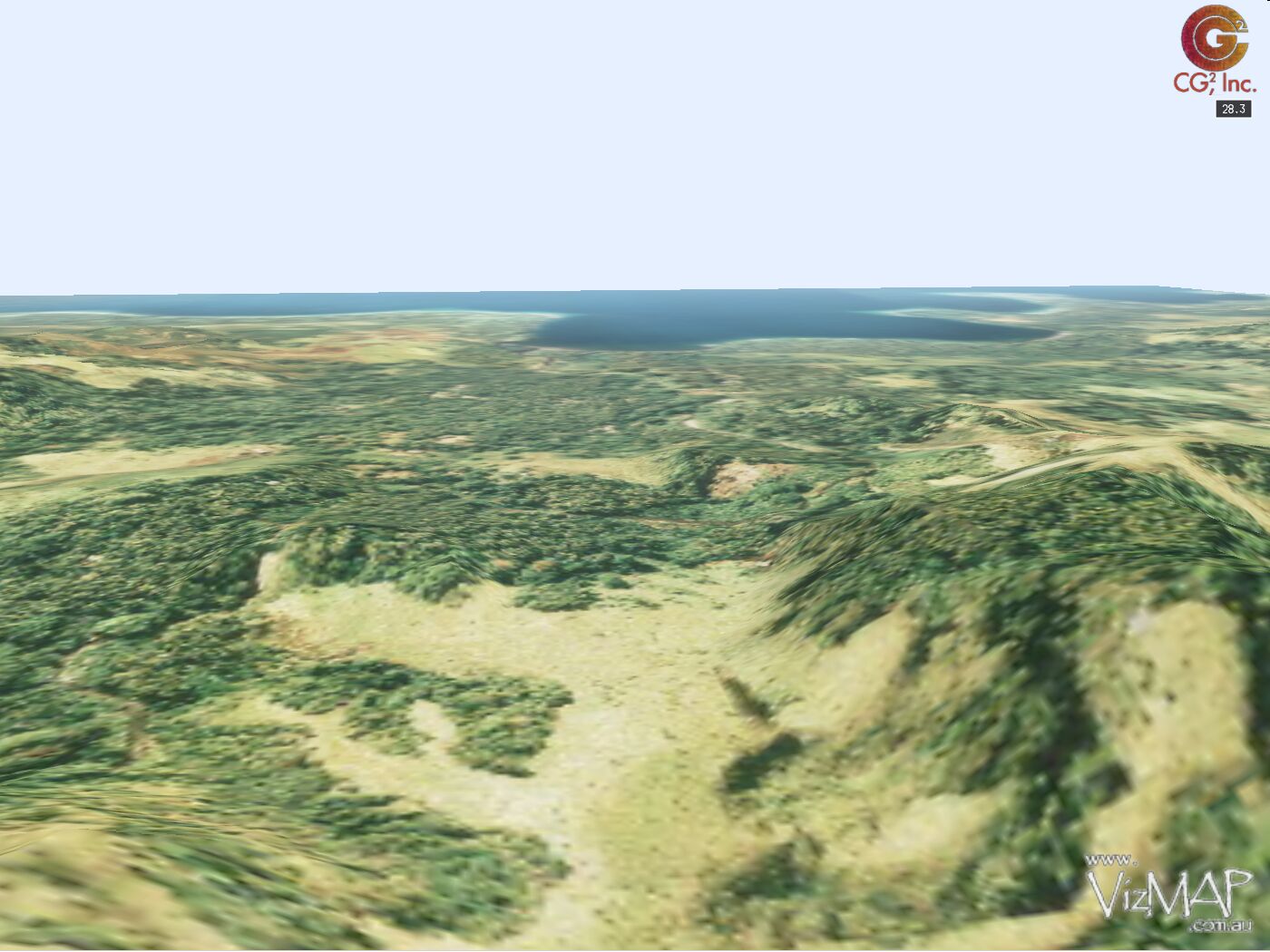
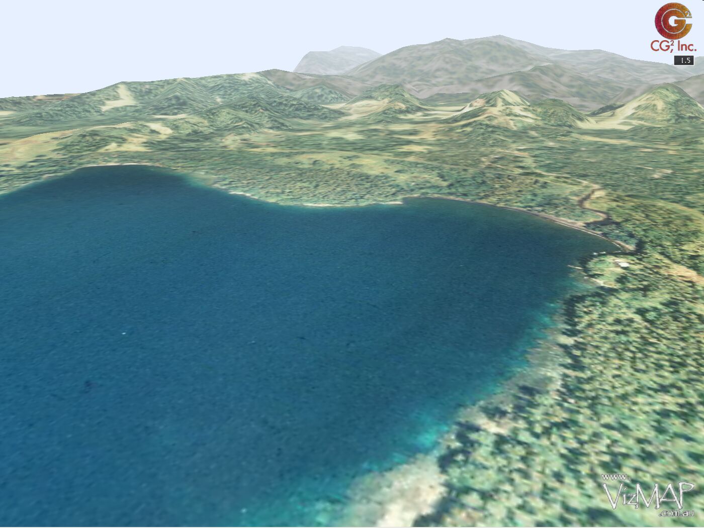
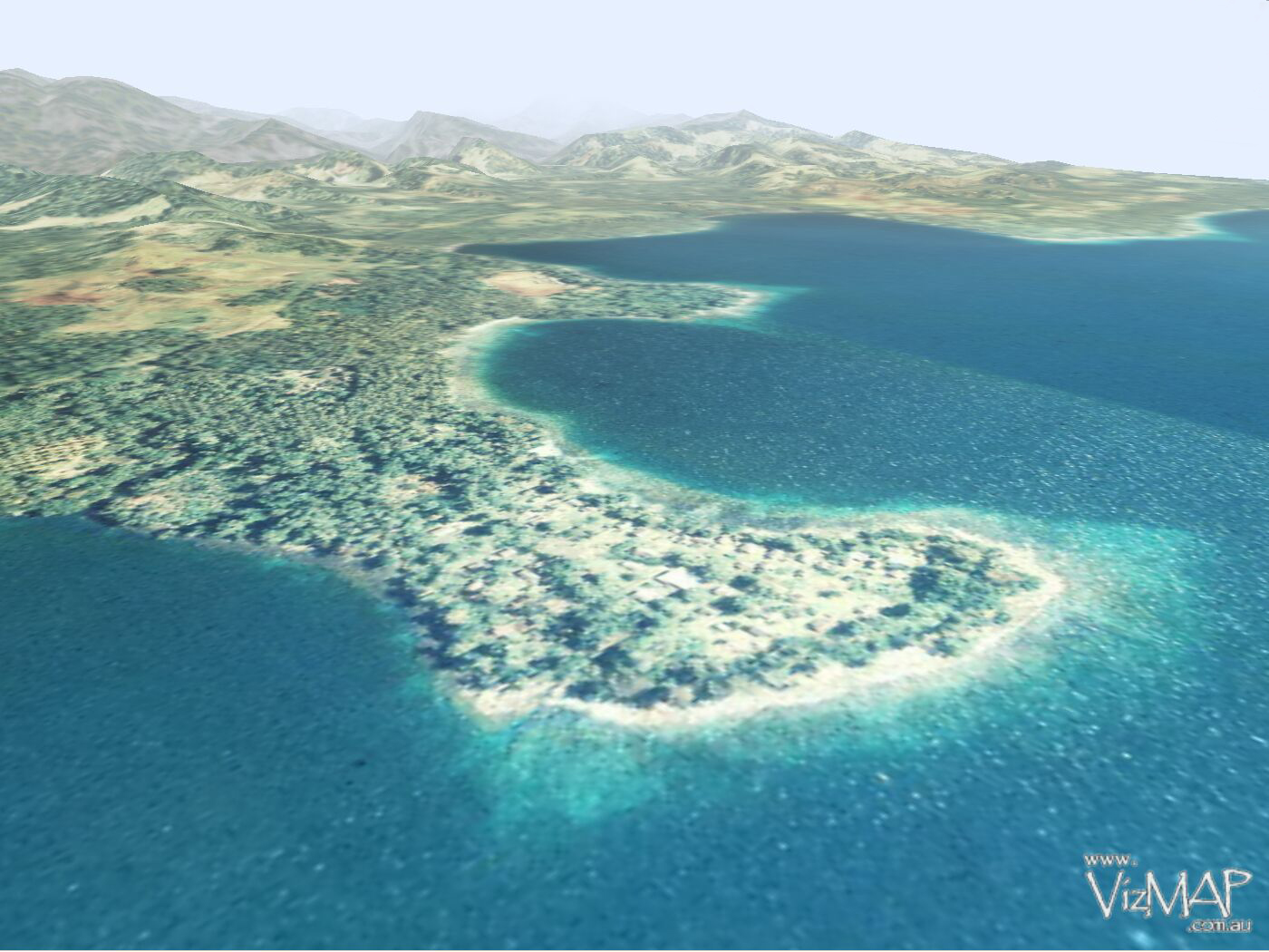
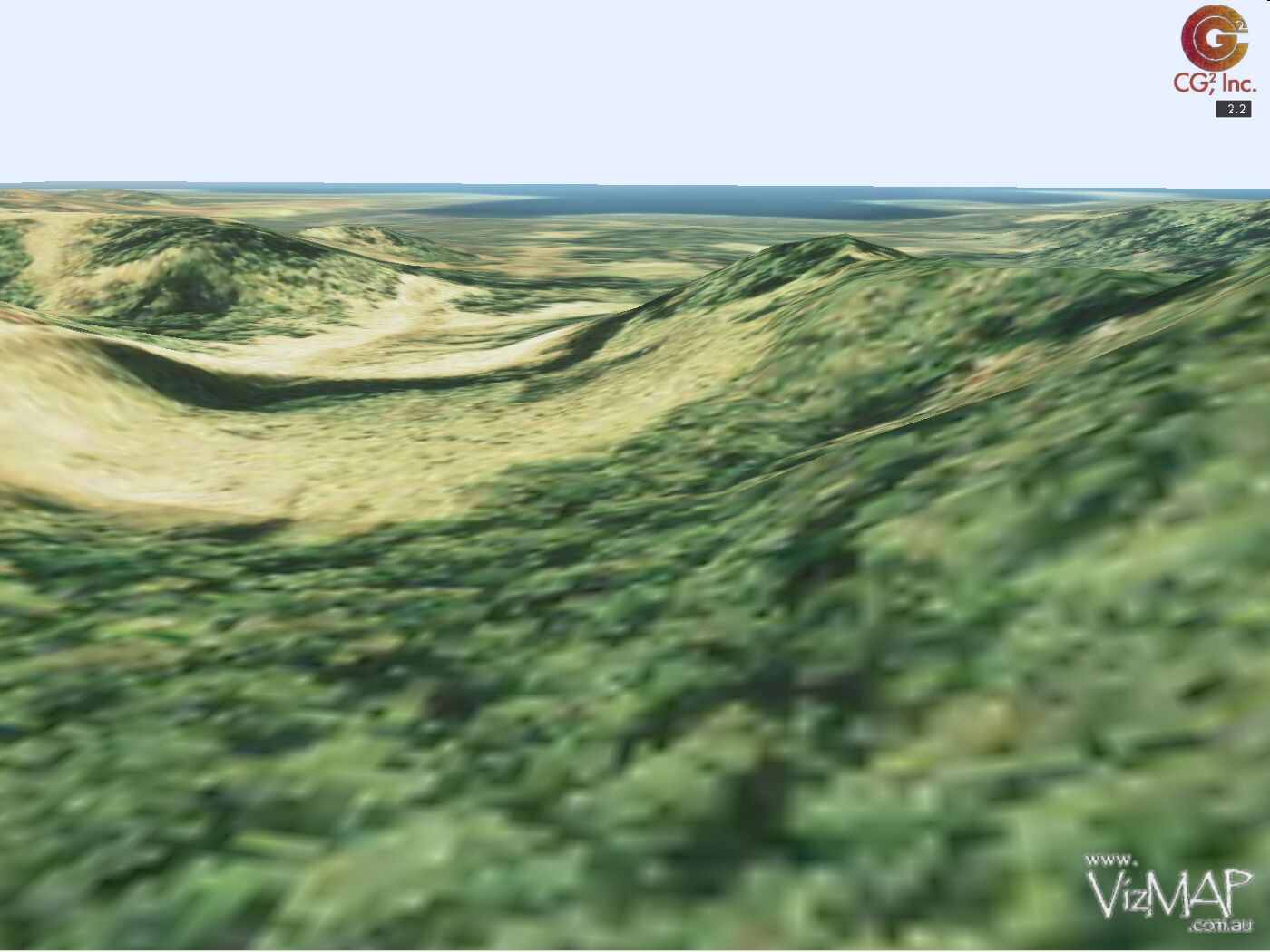
| New Guinea |
from VizMAP |
| A couple of databases were created with orthorectified aerial photography and DEM’s from New Guinea for Brisbane based Airesearch Mapping (now Fugro). The data was to help gain a contract for an engineering project.
Sample still images from the completed dynamic visualisations are displayed here. An active internet connection is required to be able to view these scenes.
Click on these small resampled images to view the full screen images on the VizMAP website. Bear in mind that these are just screen dumps from a dynamic, interactive, 3D "flythrough".
|
| If you have a need to dynamically visualise your geographic data, let VizMAP knowyour requirements… |
Back to Top |
| Geographical Trivia |
from Useless Facts |
- Los Angeles’s full name is: "El Pueblo de Nuestra Senora la Reina de los Angeles de Poriuncula" and can be abbreviated to 3.63% of its size, "LA."
- When Portland, Oregon change the name of Union Ave to Martin Luther King Blvd, it lost the intersection of Union Ave and Division Street.
- The most western point in continental Europe is Cabo de Roche in Portugal.
- The longest place name still in use is: Taumatawhakatangihangaoauauotameteaturipukakapikimaungahoronukupokaiwhenuakitanatahu – a New Zealand hill.
- Alaska was purchased from Russia for 2 cents per acre
- Mexico’s east coast is sinking into the sea at the rate of one to two inches per year.
- In the United States there are more 2nd streets than there are 1st streets, and Main street is not the most common; Pine is.
- Many people think that the clock in the tower of Londons House Of Parliment is called "Big Ben." Actually, the nickname "Big Ben" originally applied to the huge bell in the clock, not to the clock itself.
- The only nation whose name begins with an "A", but doesn’t end in an "A" is Afghanistan.
- You can call it England, Britain, Great Britain, United Kingdom, or U.K. – however if you buy a stamp there, you won’t find any name. England was the first country in the world to issue postage stamps, and they’re the only nation in the world today that doesn’t use a national name on their stamps
|
| Read that full story here |
Back to Top |
| Whazzup Next – with 20/20 Foresight… |
| Stuff to look out for in October & November |
This calendar of events has been collated from:
|
| 29th September – 2nd October 2002 |
International City/County Managers Association-Annual Meeting |
Philadelphia, PA USA |
| 30th September – 2nd October 2002 |
Mobile Location Services 2002 |
London, United Kingdom |
| October 1 – 4, 2002 |
7th Annual MobileEXPO Utility Forum |
Mesa, AZ USA |
| 1-5 Oct 2002 |
Celebrating 50 Years of Geodetic Science ISPRS Commission II |
Columbus,Ohio, USA |
| 2-4 October, 2002 |
3rd Conference on Municipal Information Systems
"Digital town and local e-government" |
Prague, CZECH Republic |
| 2-4 October, 2002 |
2002 West Virginia GIS Forum and Exhibition |
Charleston, WV, USA |
| 2-4 October, 2002 |
The Minnesota GIS/LIS Consortium 12th Annual Conference & Workshops |
Duluth, MN USA |
| 2-5 October, 2002 |
23rd Urban Data Management Symposium |
Prague, CZECH Republic |
| 10/2/2002 – 10/5/2002 |
Real Estate Information Professionals Association (REIPA) Conference |
New Orleans, LA |
| October 5, 2002 |
Virginia Environmental Assembly |
Williamsburg, VA USA |
| 5-9 October, 2002 |
2002 Society of American Foresters Annual Convention |
Winston-Salem, NC USA |
| October 7 – 9, 2002 |
Smart Card Alliance Annual Conference |
Scottsdale, AZ USA |
| 10/7/2002 – 10/9/2002 |
Location-Based Services Summit |
Atlanta, GA USA |
| 7-11 October, 2002 |
GEOEXPO 2002 – IV International Congress |
Lima, Peru |
| 8 October, 2002 |
Product Insight Seminar – CanMap® RouteLogistics V6.2 |
Markham, Ontario Canada |
| 8-10 October, 2002 |
GIS in the Rockies 2002 |
Denver, USA |
| 8-10 October, 2002 |
ESRI’s 6th Annual MEA User Conference |
Dubai, UAE |
| 8-10 October, 2002 |
GeoTech 2002: ASPRS Potomac Region Conference |
Silver Springs, MD USA |
| 9-12 October, 2002 |
NACIS(XXII) |
Columbus, OH USA |
| October 9 – 14, 2002 |
Frankfurt Book Fair |
Frankfurt, Germany |
| 10/9/2002 |
MapInfo User Group UK |
Cardiff, Scotland |
| 10-11 October, 2002 |
18th Annual New York State Geographic Information Systems Conference |
Liverpool, New York, USA |
| 10-12 October, 2002 |
Seminar about the results of three research projects of the European Organisation for Experimental Photogrammetric Research (OEEPE) |
Aalborg, Denmark |
| 10-19 Oct 2002 |
IAF/COSPAR World Space Congress |
Houston, Texas, USA |
| 11-12 Oct 2002 |
CACI InSite and Finance Conference |
North Warwickshire, UK |
| 11-15 Oct 2002 |
AASHTO Annual Meeting |
Anchorage, AK USA |
| 14-15 Oct 2002 |
3rd International Workshop on Incremental Updating and Versioning of Spatial Data Bases ISPRS IC WG II/IV |
Frankfurt, GERMANY |
| 14-16 October, 2002 |
17th ESRI European User Conference 2002 |
Bruges, Belgian Coast, Belgium |
| 14-16 October, 2002 |
2002 ESRI Electric and Gas User Group Meeting |
Coeur d’Alene, ID |
| 14-18 October, 2002 |
Ninth World Congress on Intelligent Transportation Systems |
Chicago, Illinois |
| 14-18 October, 2002 |
4th African Association of Remote Sensing of the Environment (AARSE) Conference |
Abuja, NIGERIA |
| 15 October, 2002 |
DMTI Spatial Product Insight Seminar |
Markham, Ontario Canada |
| 15-17 October, 2002 |
GW02 – Geodatische Woche 2002 |
Frankfurt am Main, Germany |
| 16-18 October, 2002 |
INTERGEO |
Frankfurt am Main, Germany |
| 16-18 October, 2002 |
NC URISA 2002 FALL CONFERENCE |
Cherokee, North Carolina USA |
| 16-18 October, 2002 |
CTIA WIRELESS I.T. & INTERNET 2002 |
Las Vegas, NV USA |
| 21-25 Oct 2002 |
VII International Congress on Earth Sciences |
Santiago, CHILE |
| October 21 – 25, 2002 |
Southwest User Group (SWUG) 2002 Conference & Workshops |
Taos, NM USA |
| 20-22 October 2002 |
19th Annual MX Association Conference |
Brisbane, Queensland, Australia |
| 10/20/2002 – 10/22/2002 |
UtiliComms Exchange for the Americas (UCX) |
Huntsville, AL USA |
| 20-23 October 2002 |
GE Network Solutions Americas Users Conference and Exhibition 2002 |
Keystone, CO USA |
| 22 Oct 2002 |
DMTI Spatial Product Insight Seminar – Postal Code Products V6.2 |
Markham, Ontario Canada |
| 22-23 Oct 2002 |
International Symposium on interaction between volcanoes and their basement and related geological hazards |
Santiago, CHILE |
| 22-24 October, 2002 |
International Symposium and Exhibition on Geoinformation 2002 |
Kuala Lumpur, Malaysia |
| October 23, 2002 |
GITA Webcast |
USA |
| 23-27 Oct 2002 |
SPIE’s Third International Asia-Pacific Symposium on Remote Sensing of the Atmosphere, Environment, and Space |
Hangzhou, CHINA |
| 24 October, 2002 |
The Fourth Annual One Day GeoBusiness Conference 2002 |
London, United Kingdom |
| October 24-25, 2002 |
Location-Based Services |
Reston, VA USA |
| 10/24/2002 – 10/25/2002 |
Asian GPS Conference |
New Delhi, India |
| 10/26/2002 |
GeoData Alliance – Annual Meeting |
Chicago, IL USA |
| 26-29 October, 2002 |
3rd International Symposium on Sustainable Agro-environmental Systems: New Technologies and Applications |
Cairo, Egypt |
| October 26-30, 2002 |
URISA’s 40th Annual Conference |
Chicago, IL USA |
| 28-29 October, 2002 |
Virginia GIS Conference 2002 |
Roanoke, VA USA |
| 28-30 October, 2002 |
2nd International eCognition User Meeting |
Miesbach, Germany |
| 10/29/2002 – 10/31/2002 |
Maximising the Potential of Mobile Location Services |
London, UK |
| 29 October – 1 November, 2002 |
OSEA2002 |
Suntec, Singapore |
| 30-31 October, 2002 |
Geomatics 2002: Everywhere for Everyone! |
Montréal, Canada |
| 30-31 October, 2002 |
Asian GPS Conference |
New Delhi, India |
| November 3 – 6, 2002 |
The Northeast ARC User Group |
Bretton Woods, New Hampshire USA |
| 11/3/2002 – 11/8/2002 |
ESRI Southeast Regional User Group Meeting |
Chattanooga, TN USA |
| 4-5 November |
Bentley Geoengineering Summit |
Madrid, Spain |
| 11/4/2002 – 11/5/2002 |
Annual Conference of the Illinois Geographic Information Systems Association |
Lisle, Illinois USA |
| November 5 – 7, 2002 |
Virginia Water Research Symposium |
Richmond, VA USA |
| 6 November |
Historical Outlook: Introduction to Historical Imagery |
Birmingham, UK |
| November 6-8, 2002 |
Energy Information Technology Conference & Expo |
Las Vegas USA |
| 11/7/2002 |
2002 Virginia Crime Analysis Vendor Fair |
Chesterfield, VA USA |
| 7-8 November |
Space Information Symposium – Technologies, Acquisition, Processing & Effective Application |
Sofia, BULGARIA |
| 8-9 November |
ACM-GIS 2002 Call for Paper – The 10th ACM International Symposium on Advances in GIS |
McLean, VA USA |
| 8-15 November |
15th William T. Pecora Memorial Remote Sensing Symposium/Land Satellite Information IV Conference and Exhibition jointly with the ISPRS Commission I (Platforms & Sensors) Symposium |
Denver, Colorado USA |
| November 10 – 11, 2002 |
Virginia Association of Counties (VACO) |
Bath County, VA USA |
| 11-15 Nov 2002 |
UN Regional Workshop on the Use of Space Technology for Disaster Management for Asia and the Pacific |
Bangkok, THAILAND |
| 11-15 Nov 2002 |
Symposium of Commission I, Joint meeting with Pecora XV |
Denver, Colorado USA |
| November 12, 2002 |
DMTI Spatial Product Insight Seminars |
Markham, Ontario, Canada |
| November 12-14, 2002 |
EnTech West ’02 – Environmental Management & Technology Conference and Exhibition |
Long Beach, CA USA |
| 11/12/2002 – 11/14/2002 |
GTC Southeast 2002 |
Atlanta, GA USA |
| 12-15 November 2002 |
NAVSAT 2002 – The Satellite Navigation and Positioning World Show |
Nice-Acropolis, France |
| November 13 – 14, 2002 |
Geospatial Intelligence Conference: The Association of Old Crows and the National Imagery and Mapping Agency (NIMA) |
Chantilly, VA USA |
| November 13-15, 2002 |
Municipal Software’s 2002 CityView User Conference |
Chicago USA |
| 11/13/2002 – 11/16/2002 |
NovaLIS User Conference"Coming Together" |
Daytona, FL USA |
| November 14-15, 2002 |
The 1st Annual North Florida GIS Conference |
Tallahassee/Big Bend, FL USA |
| 14-16 November |
International Map Trade Association Conference |
Wellington; New Zealand |
| 11/14/2002 – 11/19/2002 |
MapWorld User Conference 2002 |
San Diego, CA USA |
| Nov 15-20, 2002 |
MapInfo User Week |
San Diego, California USA |
| 11/16/2002 – 11/20/2002 |
CoreNet Global Summit |
San Diego, CA USA |
| 18-22 Nov 2002 |
International Conference on Fuzzy Systems and Knowledge Discovery (FSKD’02) |
SINGAPORE |
| 18-22 Nov 2002 |
9th International Conference on Neural Information Processing (ICONIP’02) |
SINGAPORE |
| 18-22 Nov 2002 |
4th Asia-Pacific Conference on Simulated Evolution And Learning (SEAL’02) |
SINGAPORE |
| 18th to 22nd November 2002 |
GIS in Telecoms |
Las Vegas, NV USA |
| November 19, 2002 |
DMTI Spatial Product Insight Seminars |
Markham, Ontario, Canada |
| 19th – 21st November 2002 |
IIR’s European LBS Forum |
Nice, France |
| 20 November |
GIS Day 2002 |
Worldwide |
| 24-27 November |
22nd Annual ALGIM (Association of Local Government Information Management) Conference |
Taupo, NZ |
| 25-29 Nov 2002 |
23rdACRS of AARS, "ACRS 2002" |
Kathmandu, NEPAL |
| 25-30 November |
e-future: into the mainstream; AURISA/ISA Joint 2002 Conference (bringing together AURISA 2002 and 3rd Trans Tasman Surveyors Conferences) |
Adelaide, South Australia |
| November 26, 2002 |
DMTI Spatial Product Insight Seminars |
Markham, Ontario, Canada |
|
| |
Back to Top |
| A Balance |
Very loosely "geographic" in nature from someone I know |
| Once upon a time in the Kingdom of Heaven, God went missing for six days. Eventually, Michael the Archangel found him on the seventh day, having a rest. He inquired of God, "Where have you been?"
God sighed a deep sigh of satisfaction and proudly pointed downwards through the clouds, "Look Michael! Look what I have made."
Archangel Michael looked puzzled and said, "What is it?"
"It’s a planet", replied God, "and I’ve put LIFE on it. I’m going to call it Earth and it’s going to be a great place of balance."
"Balance?" inquired Michael, still confused.
God explained, pointing to different parts of Earth. "For example, Northern Europe will be a place of great opportunity and wealth while Southern Europe is going to be poor; the Middle East over there will be a hot spot. Over there I’ve placed a continent of white people and over there is a continent of black people." God continued, pointing to different countries. "And over there, I call this place America. North America will be rich, powerful and cold, while South America will be poor, hot and friendly. And the little spot in the middle is Central America which is a hot spot. Can you see the balance?"
"Yes" said the Archangel, impressed by God’s work, then he pointed to a large land mass and asked, "What’s that one?"
"Ah", said God, "That’s Australia, the most glorious place on Earth! There are beautiful mountains, rainforests, rivers, streams and an exquisite coast line. The people are good looking, intelligent and humorous and they’re going to be found travelling the world. They’ll be extremely sociable, hard-working, and high-achieving, and they will be known throughout the world as diplomats and carriers of peace. I’m also going to give them super-human, undefeatable cricket and rugby players, who will be admired and feared by all who come across them."
Michael gasped in wonder and admiration but then declared, "But you said there will be BALANCE!?"
God replied wisely, "Wait until you see the ugly, whining, sheep-loving bunch I’m putting next to them."
Ed. – Apologies to the "ugly, whining, sheep-loving bunch" amongst us, but this one just tickled my fancy…
|
|
Back to Top |

Feel free to forward this to whomsoever you wish.
To e-mail the VirtualGeography Editor, click here.
To subscribe to VirtualGeography, click here.
To unsubscribe to VirtualGeography, click here.
…that’s all, folks! (for now).
|
|
VizMAP
- Bureau & Services Portfolio
- Contact Us
- News
- Gladstone Port Access Road nearly complete after VizMAP visualisation convinces Council
- TerraTools Exporter for Virtual Battlespace 2 (VBS2) Now Available – 23/3/9
- Updated interactive “Flash Map” of Advanced Mining Projects in Queensland by VizMAP to be distributed to delegates of Mining 2006
- VizMAP & E2E deliver workshop at Queensland Spatial Conference, Brisbane, Queensland – 17/7/8
- VizMAP creates “virtual trek” to the Everest Base Camp
- VizMAP creates virtual coal mine for central Kalimantan
- VizMAP develops interactive “Flash Map” of Advanced Mining Projects in Queensland
- VizMAP imagery of Virtual Surat Energy Province awarded image of the month by Image Society Inc.
- VizMAP Launched
- VizMAP launches FlyLG: computer based geospatial Visualisation tailored to Australian local government areas
- VizMAP presents at Australia Pacific Spatial Innovation Conference 08, Canberra, ACT – 19/11/8
- VizMAP presents at GITA 07, Brisbane, Queensland – 8/8/7
- VizMAP presents at GITA Seminar, Darwin, Northern Territory – October, 2006
- VizMAP presents at Queensland Spatial Conference 2008, Brisbane, Queensland – 18/7/8
- VizMAP presents at Surveying and Spatial Sciences Institute (SSSI) Meeting, Hervey Bay
- VizMAP Presents TerraTours® Visualization at World Energy Congress
- VizMAP presents to Darling Downs Interest Group in GIS and Remote Sensing (DIGGARS) Seminar, USQ, Toowoomba, Queensland – 8/11/7
- VizMAP presents to International Map Trade Association (IMTA), Surfer’s Paradise, Queensland – 2/11/7
- VizMAP presents to Queensland Spatial Industry Council (QSIC), Brisbane, Queensland – 22/11/7
- VizMAP writes for Position Magazine – “The 3D Industry” – April-May 2007, No 28
- VizMAP’s Virtual Surat Energy Province
- VirtualGeography Index
- VizMAP
|