|
|
vol 5 num 1

from VizMAP – letting you see where you stand…
Volume 5 Number 1
|
About VizMAP
VizMAP Pty Ltd, is a leading supplier of terrain Visualisation and related services to the defence, GIS, environmental, mapping, mining and exploration industries, engineering and construction firms, developers and planners, as well as government administration departments dealing with land, transportation and the environment.
VizMAP’s products are designed to be run on reasonably to highly configured graphics computers (PC, Linux and Unix) for public display, group training, mission rehearsal, environmental monitoring, etc. and to enhance management decision making.
VizMAP is headquartered on Queensland’s Sunshine Coast (Australia) with affiliation in Asia, Europe, Africa and the USA and thereby provides support and services to customers worldwide.
If you need to visualise anything geographic, e-mail VizMAP here with the details.
For more information about VizMAP visit the VizMAP Web site at http://www.vizmap.com.au.
|
VirtualGeography
Subscription
Details
To subscribe to VirtualGeography,
click here.
To unsubscribe from VirtualGeography,
click here.
|
A Moment’s Notice
"Sometimes when I reflect back on all the wine I drink I feel shamed. Then I look into the glass and think about the workers in the vineyards and all of their hopes and dreams If I didn’t drink this wine, they might be out of work and their dreams would be shattered. Then I say to myself, "It is better that I drink this wine and let their dreams come true than be selfish and worry about my liver." ~ Jack Handy

|
|
VirtualGeography – the newsletter
|
| G’Day… and Welcome to VirtualGeography |
from here |
| Welcome to another free VirtualGeography from VizMAP Pty Ltd.
VizMAP has been busy for the first part of this year creating yet another Flash Map for the Queensland Government Department of Natural Resources and Mines (and now Water – NRMW) – this one entitled Advanced Mining Projects (you’ll need the Flash plugin on your browser to view this). Also there were a couple of projects for a large Federal Government organisation who will remain nameless for the time being. Another one was commercial in confidence for a private Queensland company so you’ll have to wait to see that one too. What I CAN tell you now, 4 years after the fact, is that VizMAP was responsible for all the digital mapping that the Australian Federal Police used for their online (and in-field) security mapping requirements for the Commonwealth Heads of Government Meeting (CHOGM) back in 2002. Something more recently (actually last week) that we did for GITA was a heads-up graphic using Google Earth to detail the dams and freshwater lakes in south east Queensland. If you have Google Earth installed you can click on this link to have a look at that. If you don’t have Google Earth, you ought to. Get it here. We’ve also been involved in creating Google Earth scenarios for a Sydney based photogrammetry based organisation. Since the last Virtual Geography I have also been to I/ITSEC and had "train the trainer training" at TerraSim in Pittsburgh. This may not be a big thing for people sitting in the Eastern quarter of the US, but for a Mooloolaba guy, it was a significant trip. Thanks go to the "sponsors" at TerraSim, esp. Dave, Bill, Joe and Jules.
Never a dull moment at VizMAP.
If you didn’t already know, VirtualGeography is a collection of interesting snippets from all over the shop, dealing with industry issues concerning the computer based visualisation of geography and a few other associated (or otherwise) interesting bits and pieces. You are receiving this either because you subscribed to VirtualGeography or you have had recent dealings with VizMAP Pty Ltd. If you do not wish to receive further instalments of VirtualGeography, just click on the unsubscribe link at the bottom of this e-mail.
A new VirtualGeography is pushed out every now and then when we’ve collated enough interesting bits and pieces, which shouldn’t be too big a drain on your mailbox if you’re not already subscribed (of course it won’t be a drain on your mailbox if you ARE subscribed, either ). The regularity of the distribution may vary depending on what else is going on at VizMAP at the time. If you know of anyone who might like to get VirtualGeography, feel free to forward this to them and ask them to subscribe. By the way, subscription and unsubscription details are at the bottom (click here).
So, g’day to all you enthusiasts requiring to visualise and simulate both urban and rural geographic information (GIS), cartography, photogrammetry, remote sensing, digital elevation modelling (DEM) and general mapping.
By the spelling of "Visualisation" you may have already guessed that we’re not US based – that’s a good thing, or at least not a bad thing. This comes to you from Mooloolaba on the Sunshine Coast of Queensland, Australia, where it’s beautiful one day and perfect the next. As a postscript to that, you can have a look at the Mooloolaba beach, now, 800m from where I sit as I write this, here.
|
The link between visualisation and mapping may seem a little esoteric if this is your first encounter with this sort of stuff, but let me tell you, the bond is significant… but enough of that: on with the show… I hope you like it. Any feedback you might have is highly appreciated. E-mail me here to make your comments.
Enjoy…
Graeme Brooke
VizMAP Pty Ltd
|
 |
P.S. You’ll need an active internet connection to view any images that are in the content. We’ve done it this way to keep the size of the e-mail to a minimum.
|
| |
Back to Top |
| The Industry’s Two Cents Worth… |
| TerraSim Demonstrates Google Earth Plug-in for TerraTools 3.0 |
from TerraSim |
| TerraSim Inc. demonstrated a plug-in to their geospatial visualization product, TerraTools® 3.0, that allows their users to export TerraTools 3D databases for viewing by the Google Earth community. These Google Earth visualizations attracted more than expected interest at the TerraSim booth at I/ITSEC (Interservice/Industry Training, Simulation and Education) conference in Florida in Nov/Dec last year.
TerraSim Inc. an industry leader in geospatial simulation for urban environments, demonstrated examples of this functionality using urban mapping data from Pittsburgh and Kuala Lumpur, Malaysia. The process extracts the components of TerraTools urban database geometry and appearance that can be expressed in the Google Earth KML (Keyhole Macro Language) format.
Additional TerraTools export formats include 3ds Max®, VRML, OpenFlight®, as well as support for modeling and simulation runtime formats such as OTB (CTDB), JSAF, and OneSAF.
Joe Giuliani, Senior Computer Graphics Engineer at TerraSim remarked, "Google Earth provides the Big Picture for detailed urban visualization. Our new Google Earth export plug-in allows our customers to distribute a version of their modeling and simulation databases online for realtime streaming and download."
Using TerraSim’s GISLink™ export technology, the Google Earth visualization is fully corralated with the export of our other format variants to support modeling and simulation runtimes for training and mission rehearsal as well as civil applications in urban and transportation planning.
Graeme Brooke, President of VizMAP and the TerraSim VAR in Australia commented "The other bonus, from my perspective, is that all of a sudden, the general public is starting to think in 3D. Google have identified a niche that we’ve been beavering away at for years. The military are on top of this, but to the civilian community it’s new and exciting, which, for us, is exciting in itself. VizMAP, for example, has already performed a number of proof-of-concept Google Earth scenarios for the Australian Government which have been well received".
The GIS source data for the Kuala Lumpur visualization was provided by Espatial Resources Sdn Bhd of Kuala Lumpur. Espatial is the authorized TerraSim reseller for Malaysia, Thailand, Indonesia, and Singapore.
|
| Read that full story here |
Back to Top |
| Hardcore Stuff (hardware bits)… |
| Louisiana State University Selects SGI Technology for Storm Modeling and Scientific Visualization |
from SGI |
| Silicon Graphics Prism Visualization System Aids Hurricane Katrina Recovery Efforts; SGI Technology To Be Available to Eight Colleges and Universities Via 40 Gb Louisiana Optical Network Initiative
MOUNTAIN VIEW, Calif. (March 8, 2006)—To enable a wide range of scientific discovery efforts, including storm surge mapping of Hurricane Katrina, Louisiana State University (LSU), in August 2005, installed a powerful combination of technology from Silicon Graphics (OTC: SGID) for its Center for Computation & Technology. Purchased through James River Technical, Inc., SGI exclusive higher education reseller, the Silicon Graphics Prism™ Extreme visualization system and SGI® Visual Area Networking (VAN) technology with SGI® OpenGL Vizserver™ software will also add real-time 3D collaborative visualization to the emerging statewide 40Gb optical network called LONI (Louisiana Optical Network Initiative). LONI, which is connected to the National LambdaRail (NLR), a nationwide optical network infrastructure, will directly link the Silicon Graphics Prism™ visualization system at LSU with eight Louisiana schools including Tulane and Xavier Universities, and other smaller universities. The SGI technology purchase was made possible by grants from the National Institutes of Health (NIH) and the National Science Foundation (NSF).
The Silicon Graphics Prism visualization system, called "Santaka," after a spicy Louisiana pepper, and SGI Vizserver technology join a 1,024-processor Linux® cluster and other similar clusters in LSU’s High Performance Computing group, a joint partnership between the Center for Computation & Technology (CCT) and Information Technology Services (ITS), on the main campus in Baton Rogue. When considering the advent of LONI, and the growing computational demands in many fields, especially biology, biochemistry, computational chemistry, physics, and computational fluid dynamics, LSU’s Director of High Performance Computing (HPC) decided the time was right to bring in another system and architecture.
"After initially considering several other systems and the SGI Altix servers, I met with others in the research community here on campus to discuss their requirements," said Brian Ropers-Huilman, Director of HPC, LSU. "I had quotes from several vendors, we discussed it openly, and in the end there was much more interest in the Altix, in terms of it having a shared-memory system rather than distributed memory like our clusters. With the size of our datasets rapidly growing, everyone believed that having substantial shared memory would enable us to conduct more and better research in less time. People were also quite interested in the visualization and graphics capability that came with the name SGI. That took us down the Silicon Graphics Prism visualization path, which was extremely appealing."
|
| Read that full story here |
Back to Top |
| Softcore Stuff (software & data bits)… |
| Carbon Project Announces New Portal for the Open-Geospatial .NET Community |
from GeoLeaders |
| Washington, DC, August 1, 2005 – The Carbon Project today announced a new resource designed to help the growing Open-Geospatial .NET Community, The Carbon Portal. Through The Carbon Portal, anyone will be able to join the Open-Geospatial .NET Community at no cost, exchange ideas, source code and find support among others seeking to advance open-geospatial interoperability.
“The Carbon Portal, located at www.TheCarbonPortal.net, is designed to support the interest shown in CarbonTools and other Open-Geospatial .NET tools. For example, downloads of the CarbonTools free toolkit exceeded 2,000 in the first eight weeks after release and these users need a collaborative space to exchange ideas and code. The new Carbon Portal will extend this global interest to a broad community, helping mainstream IT users implement open-geospatial interoperability in a wide range of applications,” said Jeff Harrison, President of The Carbon Project.
Based on the Microsoft .NET Framework, CarbonTools provides a powerful and extendible API for accessing geospatial web services based on Open Geospatial Consortium (OGC™) specifications including GML, OGC’s XML encoding for geospatial information.
For information on becoming a Carbon Portal Sponsor or Forum Moderator, please contact Jeff Harrison at (703) 628-8655, or at [email protected].
Additional Information on how to leverage CarbonTools in Open-Geospatial .NET applications will be provided at the upcoming Open-Geospatial Development workshop. To register for this event please visit http://www.geoleaders.com/training.htm.
The Carbon Project is a Microsoft Certified Partner that pioneers innovative geospatial solutions and aspires to make the world of geospatial information accessible and usable to everyone. For more information please visit www.TheCarbonProject.com.
|
| Read that full story here |
Back to Top |
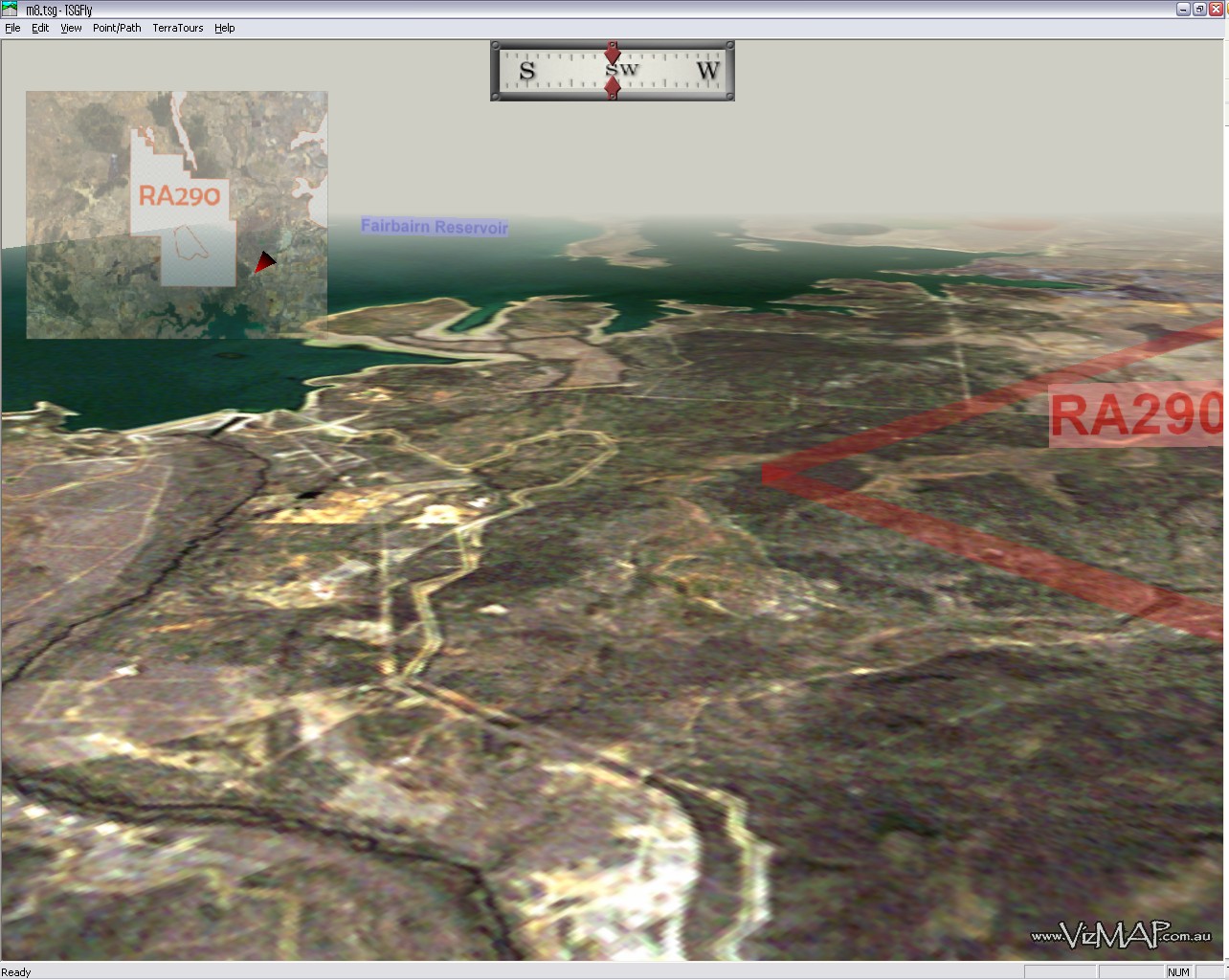
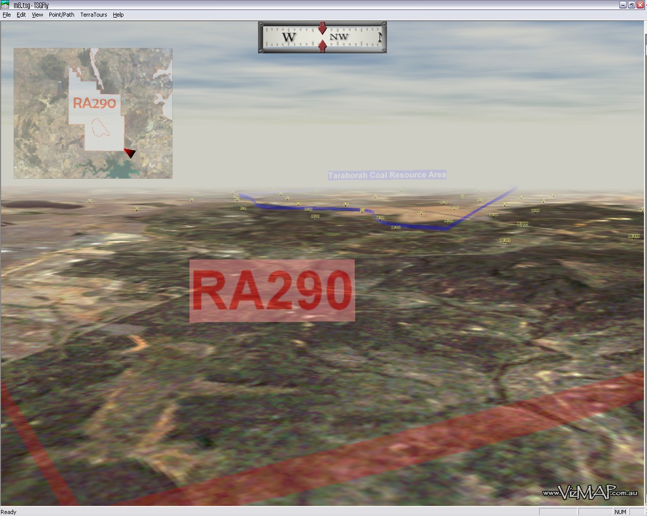
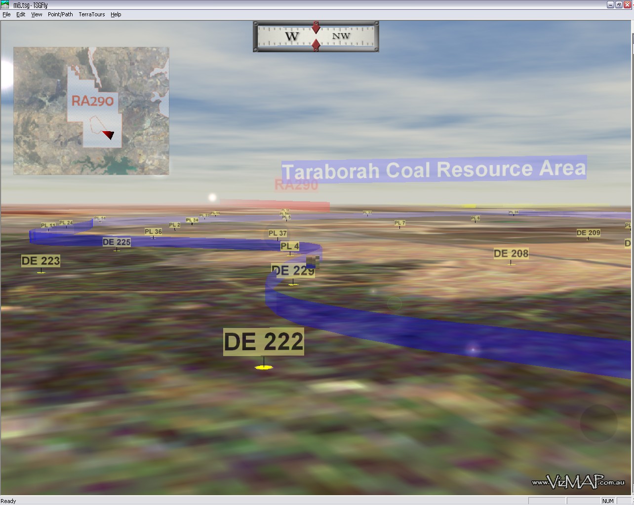
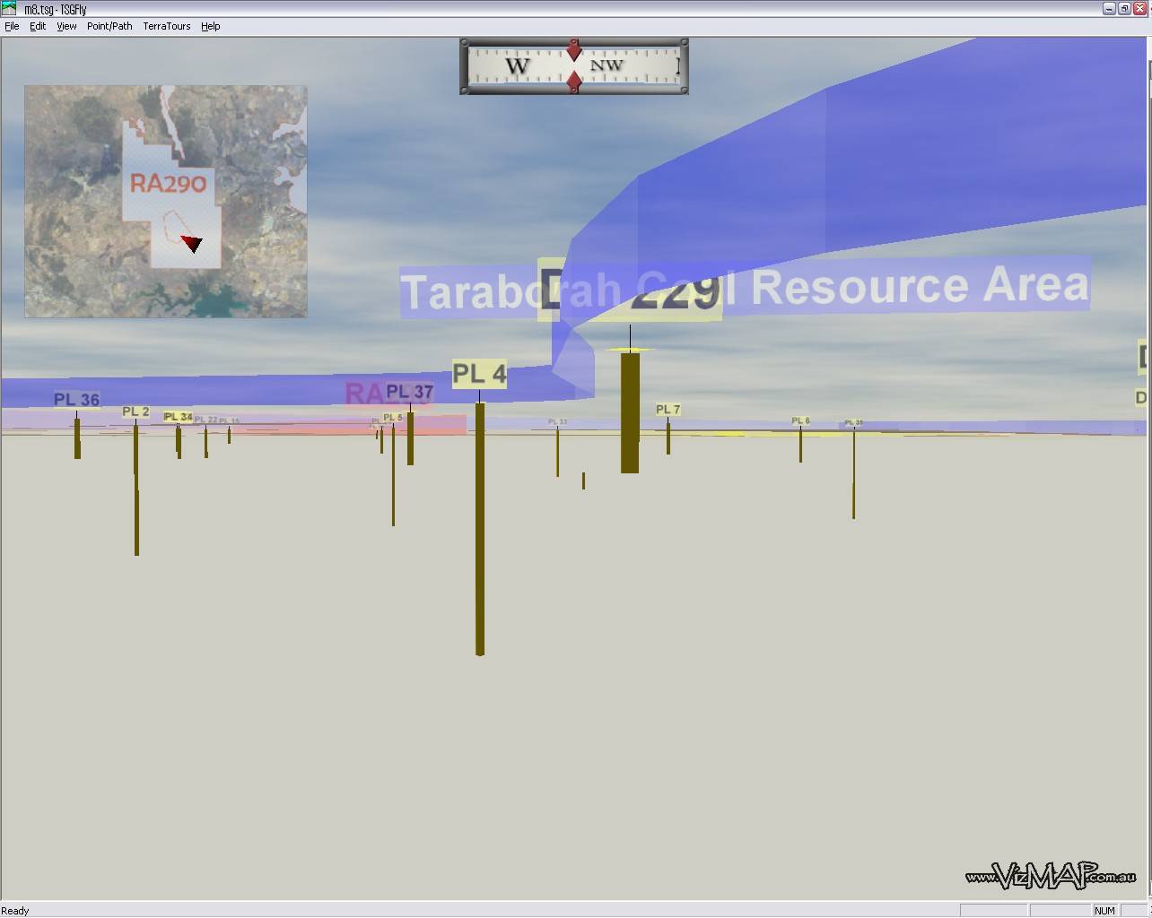
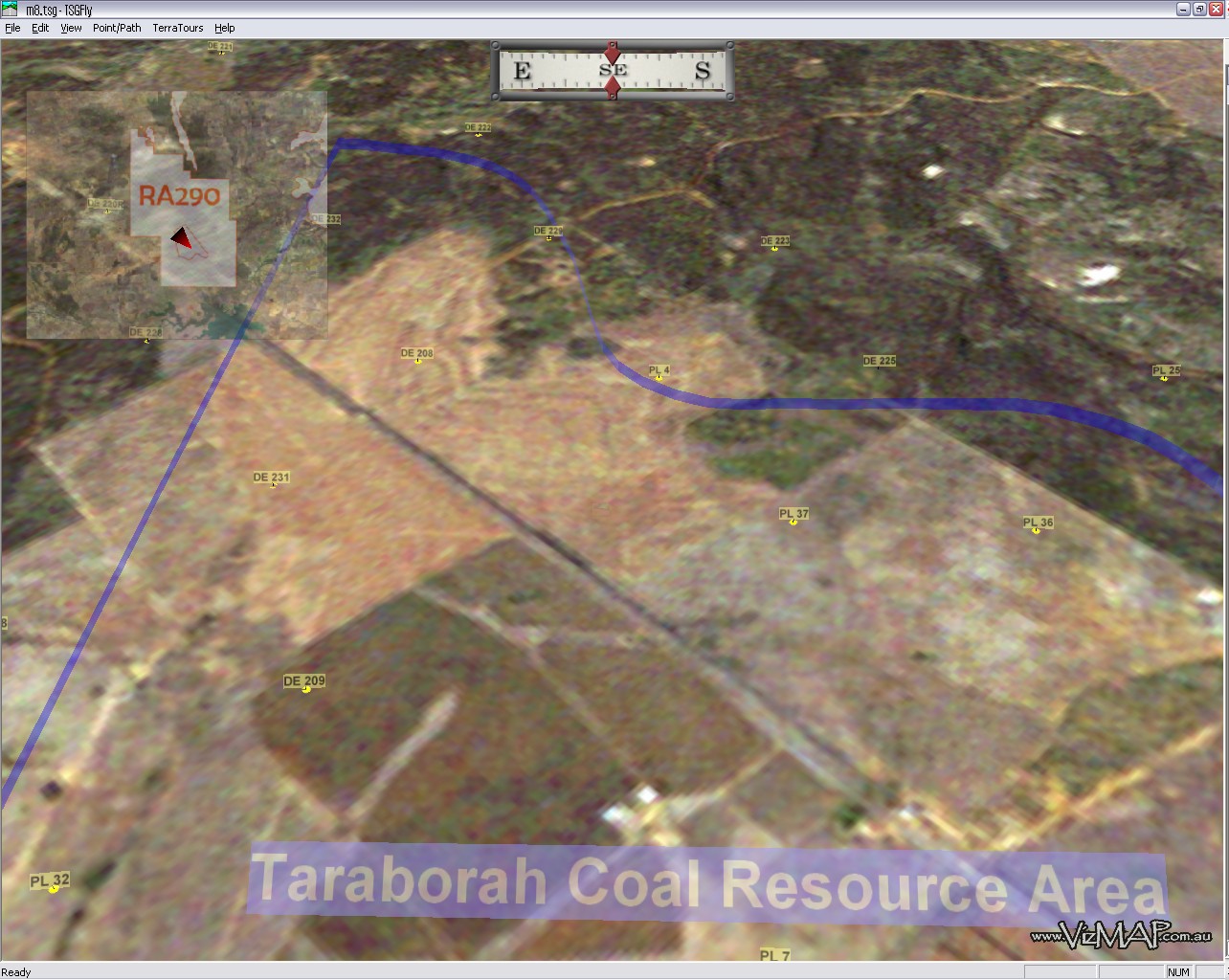
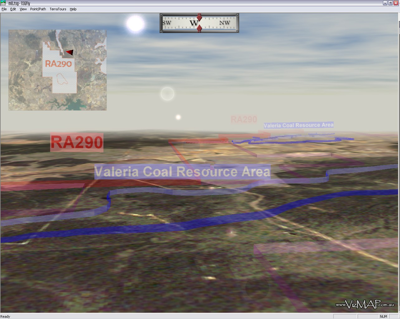
| Mining Venture Proposal at Taraborah |
from here |
| VizMAP Pty Ltd was contracted by Queensland Department of Natural Resources, Mines and Water to create a computer based visualisation of the Taraborah coal mining area of Queensland. VizMAP used TerraTools to create the visualisation and incorporated Landsat imagery, SRTM terrain data and bore hole information that was all included into the eventual visualisation.
Click on these small resampled images to view the full screen images on the VizMAP website. Bear in mind that these are just screen dumps from a dynamic, interactive application.
If you would like more information on this project, let VizMAP know
|
| If you have a need to dynamically visualise your geographic data, let VizMAP know your requirements… |
Back to Top |
| Road-Ready Night Vision at Last |
from Wired |
| MUNICH, Germany — Driving at night down a dark and isolated stretch of road off the Autobahn, one could easily believe there isn’t another soul within miles: The windshield view shows only a few yards of barren road lined with looming trees and dense shrubs. But a quick glance at the monitor in the center of the dashboard reveals the brightly illuminated image of a man moving out from behind a bush on the side of the road, beyond the ambit of the headlights, where I would never have seen him.
Mercedes and BMW hope to make night driving safer with dashboard monitors that expose what the naked eye is unable to see lurking in the dark. During exclusive test drives near the carmakers’ headquarters in Germany, Wired News experienced the night-drive systems firsthand in the new Mercedes-Benz S-Class and the BMW 7 Series. The sedans are set to launch in the United States this year.
Relying on a monitor to see what was beyond the scope of the headlights did not feel like the Blade Runner experience I had anticipated. I quickly learned how to use the two systems to ward off collision courses with the pedestrians, animals or objects that all too often make nighttime driving hazardous.
Indeed, helping to prevent thousands of deaths each year attributed directly or indirectly to night-driving hazards is the raison d’etre of the new night-vision systems, Mercedes and BMW say. According to a 2003 U.S. Department of Transportation study, more than 20 percent of fatal accidents occurred between midnight and 6:00 a.m., which accounts for only 2.4 percent of traffic volume during a 24-hour period. About half of all fatal pedestrian accidents also occur at night, the study said, when fewer people are out and about.
|
| Read that full story here |
Back to Top |
| Whazzup Next – with 20/20 Foresight… |
| Check these sites for events to look out for in the Vis/Sim, GIS, LIS, Remote Sensing & Photogrammetry calendars… |
|
| |
Back to Top |
| A Parting Gesture… |
| HEALTH QUESTION & ANSWER SESSION |
From Grime |
| HEALTH QUESTION & ANSWER SESSION
Q: I’ve heard that cardiovascular exercise can prolong life; is this true?
A: Your heart is only good for so many beats, and that’s it… don’t waste them on exercise. Everything wears out eventually. Speeding up your heart will not make you live longer; that’s like saying you can extend the life of your car by driving it faster. Want to live longer? Take a nap.
Q: Should I cut down on meat and eat more fruits and vegetables?
A: You must grasp logistical efficiencies. What does a cow eat? Hay and corn. And what are these? Vegetables. So a steak is nothing more than an efficient mechanism of delivering vegetables to your system. Need grain? Eat chicken. Beef is also a good source of field grass (green leafy vegetable). And a pork chop can give you 100% of your recommended daily allowance of vegetable products.
Q: Should I reduce my alcohol intake?
A: No, not at all. Wine is made from fruit. Brandy is distilled wine, that means they take the water out of the fruity bit so you get even more of the goodness that way. Beer is also made out of grain. Bottoms up!
Q: How can I calculate my body/fat ratio?
A: Well, if you have a body and you have fat, your ratio is one to one. If you have two bodies, your ratio is two to one, etc.
Q: What are some of the advantages of participating in a regular exercise program?
A: Can’t think of a single one, sorry. My philosophy is: No Pain…Good!
Q: Aren’t fried foods bad for you?
A: YOU’RE NOT LISTENING!!!… Foods are fried these days in vegetable oil. In fact, they’re permeated in it. How could getting more vegetables be bad for you?
Q: Will sit-ups help prevent me from getting a little soft around the middle?
A: Definitely not! When you exercise a muscle, it gets bigger. You should only be doing sit-ups if you want a bigger stomach.
Q: Is chocolate bad for me?
A: Are you crazy? HELLO . Cocoa beans! Another vegetable!!! It’s the best feel-good food around!
Q: Is swimming good for your figure?
A: If swimming is good for your figure, explain whales to me.
Q: Is getting in-shape important for my lifestyle?
A: Hey! ‘Round’ is a shape!
Well, I hope this has cleared up any misconceptions you may have had about food and diets.
And remember:
"Life should NOT be a journey to the grave with the intention of arriving safely in an attractive and well preserved body, but rather to skid in sideways – Chardonnay in one hand – chocolate in the other – body thoroughly used up, totally worn out and screaming "WOO HOO, What a Ride!"
|
|
Back to Top |
|
Feel free to forward this to whomsoever you wish.
To e-mail the VirtualGeography Editor, click here.
To subscribe to VirtualGeography, click here.
To unsubscribe from VirtualGeography, click here. |
| |
…that’s all, folks! (for now).
|
|
VizMAP
- Bureau & Services Portfolio
- Contact Us
- News
- Gladstone Port Access Road nearly complete after VizMAP visualisation convinces Council
- TerraTools Exporter for Virtual Battlespace 2 (VBS2) Now Available – 23/3/9
- Updated interactive “Flash Map” of Advanced Mining Projects in Queensland by VizMAP to be distributed to delegates of Mining 2006
- VizMAP & E2E deliver workshop at Queensland Spatial Conference, Brisbane, Queensland – 17/7/8
- VizMAP creates “virtual trek” to the Everest Base Camp
- VizMAP creates virtual coal mine for central Kalimantan
- VizMAP develops interactive “Flash Map” of Advanced Mining Projects in Queensland
- VizMAP imagery of Virtual Surat Energy Province awarded image of the month by Image Society Inc.
- VizMAP Launched
- VizMAP launches FlyLG: computer based geospatial Visualisation tailored to Australian local government areas
- VizMAP presents at Australia Pacific Spatial Innovation Conference 08, Canberra, ACT – 19/11/8
- VizMAP presents at GITA 07, Brisbane, Queensland – 8/8/7
- VizMAP presents at GITA Seminar, Darwin, Northern Territory – October, 2006
- VizMAP presents at Queensland Spatial Conference 2008, Brisbane, Queensland – 18/7/8
- VizMAP presents at Surveying and Spatial Sciences Institute (SSSI) Meeting, Hervey Bay
- VizMAP Presents TerraTours® Visualization at World Energy Congress
- VizMAP presents to Darling Downs Interest Group in GIS and Remote Sensing (DIGGARS) Seminar, USQ, Toowoomba, Queensland – 8/11/7
- VizMAP presents to International Map Trade Association (IMTA), Surfer’s Paradise, Queensland – 2/11/7
- VizMAP presents to Queensland Spatial Industry Council (QSIC), Brisbane, Queensland – 22/11/7
- VizMAP writes for Position Magazine – “The 3D Industry” – April-May 2007, No 28
- VizMAP’s Virtual Surat Energy Province
- VirtualGeography Index
- VizMAP
|